
Fai una donazione
Equipaggiati per la tua prossima avventura:
In qualità di Affiliato Amazon, questo sito riceve una commissione sugli acquisti idonei, senza costi aggiuntivi per l’utente.
Mappa topografica West Bromwich
Clicca sulla mappa per visualizzare l'altitudine.
Fai una donazione
Equipaggiati per la tua prossima avventura:
In qualità di Affiliato Amazon, questo sito riceve una commissione sugli acquisti idonei, senza costi aggiuntivi per l’utente.
West Bromwich
The town's football club is West Bromwich Albion. The club was founded in 1878 and in 1888 it became one of the 12 founder members of the Football League. It won the league championship in 1920 and has won the FA Cup five times, most recently in 1968, and won the League Cup in 1966. Albion were based in and around the centre of West Bromwich during their formative years, but moved further out of the town in 1900 when they switched to their current ground, The Hawthorns. All traces of the original structures are long gone; the present structures were added to the stadium in 1979, 1994 and most recently 2001. At an altitude of 551 feet, The Hawthorns is the highest football ground (above sea level) in the country.
Fai una donazione
Equipaggiati per la tua prossima avventura:
In qualità di Affiliato Amazon, questo sito riceve una commissione sugli acquisti idonei, senza costi aggiuntivi per l’utente.
A proposito di questa mappa
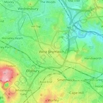
Nome: Mappa topografica West Bromwich, altitudine, rilievo.
Altitudine media: 149 m
Altitudine minima: 98 m
Altitudine massima: 270 m
Fai una donazione
Equipaggiati per la tua prossima avventura:
In qualità di Affiliato Amazon, questo sito riceve una commissione sugli acquisti idonei, senza costi aggiuntivi per l’utente.
Altre mappe topografiche
Clicca su una mappa per visualizzarne la topografia, l'altitudine e il rilievo.
Causeway Green Park
United Kingdom > England > Sandwell > Causeway Green > The Ashes
Altitudine media: 184 m
Rowley Hills
United Kingdom > England > Sandwell > Tividale
The largest hill, Turner's Hill, is the highest point in the West Midlands county, with an altitude of 269 metres (883 ft) above sea level. Views from the summit include the Clee Hills, Clent Hills, Cannock Chase, and much of Birmingham and the Black Country. The height has also led to the construction of two…
Altitudine media: 182 m