
Fai una donazione
Equipaggiati per la tua prossima avventura:
In qualità di Affiliato Amazon, questo sito riceve una commissione sugli acquisti idonei, senza costi aggiuntivi per l’utente.
Mappa topografica Kexbrough
Clicca sulla mappa per visualizzare l'altitudine.
Fai una donazione
Equipaggiati per la tua prossima avventura:
In qualità di Affiliato Amazon, questo sito riceve una commissione sugli acquisti idonei, senza costi aggiuntivi per l’utente.
Kexbrough
Kexbrough is a village in the Barnsley district, in the county of South Yorkshire, England, on the border with West Yorkshire. The village falls within the Darton West ward of Barnsley MBC. It is located west of the M1 motorway, just south of Junction 38 at an elevation of around 351 feet (107 m) above sea level. Historically the village was known as Kexborough, and includes the hamlets of Haigh and Swithin. Until 1974 it was in the West Riding of Yorkshire.
Fai una donazione
Equipaggiati per la tua prossima avventura:
In qualità di Affiliato Amazon, questo sito riceve una commissione sugli acquisti idonei, senza costi aggiuntivi per l’utente.
A proposito di questa mappa
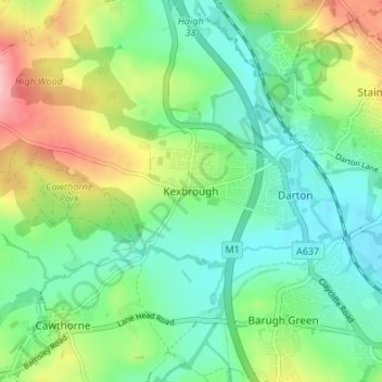
Nome: Mappa topografica Kexbrough, altitudine, rilievo.
Altitudine media: 98 m
Altitudine minima: 52 m
Altitudine massima: 194 m
Fai una donazione
Equipaggiati per la tua prossima avventura:
In qualità di Affiliato Amazon, questo sito riceve una commissione sugli acquisti idonei, senza costi aggiuntivi per l’utente.
Altre mappe topografiche
Clicca su una mappa per visualizzarne la topografia, l'altitudine e il rilievo.
Shafton
United Kingdom > England > Barnsley
Shafton lies to the north of Shafton Two Gates, on the road to Ryhill. It is located at approximately 53° 35' 10" North, 1° 24' West, at an elevation of around 262 feet (80 m) above sea level. Sceptun in the Domesday Book of 1086 then later in c. 1160 Scaftona meaning a farmstead marked by a pole, or made…
Altitudine media: 65 m
Fai una donazione
Equipaggiati per la tua prossima avventura:
In qualità di Affiliato Amazon, questo sito riceve una commissione sugli acquisti idonei, senza costi aggiuntivi per l’utente.
Fai una donazione
Equipaggiati per la tua prossima avventura:
In qualità di Affiliato Amazon, questo sito riceve una commissione sugli acquisti idonei, senza costi aggiuntivi per l’utente.
High Hoyland
United Kingdom > England > Barnsley
High Hoyland is a village and civil parish in the Metropolitan Borough of Barnsley in South Yorkshire, England, on the border with West Yorkshire. It lies to the west of Kexbrough, and is located at approximately 53°35′10″N 1°35′30″W / 53.58611°N 1.59167°W / 53.58611; -1.59167, at an…
Altitudine media: 139 m