
Fai una donazione
Equipaggiati per la tua prossima avventura:
In qualità di Affiliato Amazon, questo sito riceve una commissione sugli acquisti idonei, senza costi aggiuntivi per l’utente.
Mappa topografica Jim Thorpe
Clicca sulla mappa per visualizzare l'altitudine.
Fai una donazione
Equipaggiati per la tua prossima avventura:
In qualità di Affiliato Amazon, questo sito riceve una commissione sugli acquisti idonei, senza costi aggiuntivi per l’utente.
Jim Thorpe
In the deeps of the geologic timescale the two shorelines of the Lehigh River occupied by the 19th-century towns of Mauch Chunk and East Mauch Chunk were situated on the bottom of an ancient river-fed tarn, a mountain lake which filled the valley on the west bank and covered the relative flatlands on the east bank. The muddy bottom of that high tarn (the range then rivaling the Himalayas in size), where the waters pooled at a lower elevation amongst the twisted folds of four near-parallel ridgelines, created a level region whose settlements became the relatively flat lands on either bank of the Lehigh. The ridgelines, which run east-northeast to west-southwest, are (from north to south) Broad, Nesquehoning, Pisgah, and Mauch Chunk ridges (or Mountains)—each of which runs over 15 miles (24.1 km) west to the gaps cut by the Schuylkill River.
Fai una donazione
Equipaggiati per la tua prossima avventura:
In qualità di Affiliato Amazon, questo sito riceve una commissione sugli acquisti idonei, senza costi aggiuntivi per l’utente.
A proposito di questa mappa
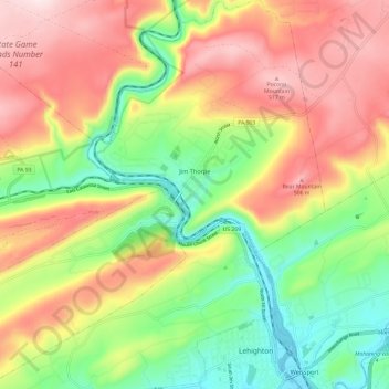
Nome: Mappa topografica Jim Thorpe, altitudine, rilievo.
Altitudine media: 332 m
Altitudine minima: 135 m
Altitudine massima: 541 m
Fai una donazione
Equipaggiati per la tua prossima avventura:
In qualità di Affiliato Amazon, questo sito riceve una commissione sugli acquisti idonei, senza costi aggiuntivi per l’utente.
Altre mappe topografiche
Clicca su una mappa per visualizzarne la topografia, l'altitudine e il rilievo.
Holiday Poconos
United States > Pennsylvania > Carbon County > Kidder Township
Altitudine media: 519 m
Fai una donazione
Equipaggiati per la tua prossima avventura:
In qualità di Affiliato Amazon, questo sito riceve una commissione sugli acquisti idonei, senza costi aggiuntivi per l’utente.
Lake Harmony
United States > Pennsylvania > Carbon County > Kidder Township > Lake Harmony
Altitudine media: 568 m
Beltzville State Park - Parking Lot B
United States > Pennsylvania > Carbon County > Lehighton
Altitudine media: 222 m
Hickory Run State Park
United States > Pennsylvania > Carbon County > Kidder Township
Altitudine media: 471 m
Fai una donazione
Equipaggiati per la tua prossima avventura:
In qualità di Affiliato Amazon, questo sito riceve una commissione sugli acquisti idonei, senza costi aggiuntivi per l’utente.
Holiday Poconos
United States > Pennsylvania > Carbon County > Kidder Township
Altitudine media: 519 m
Lake Harmony
United States > Pennsylvania > Carbon County > Kidder Township > Lake Harmony
Altitudine media: 551 m
Fai una donazione
Equipaggiati per la tua prossima avventura:
In qualità di Affiliato Amazon, questo sito riceve una commissione sugli acquisti idonei, senza costi aggiuntivi per l’utente.
Germans
United States > Pennsylvania > Carbon County > East Penn Township > Germans
Altitudine media: 238 m
Holiday Poconos
United States > Pennsylvania > Carbon County > Kidder Township
Altitudine media: 519 m