
Mappa topografica Town of Rushford
Mappa interattiva
Clicca sulla mappa per visualizzare l'altitudine.
A proposito di questa mappa
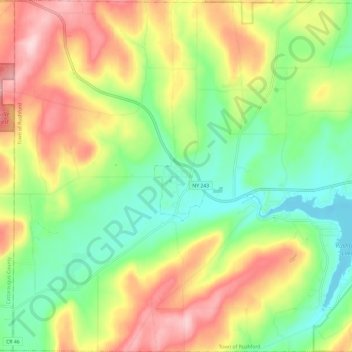
Nome: Mappa topografica Town of Rushford, altitudine, rilievo.
Luogo: Town of Rushford, Allegany County, New York, United States (42.34862 -78.30903 42.43661 -78.19132)
Altitudine media: 528 m
Altitudine minima: 430 m
Altitudine massima: 666 m
Altre mappe topografiche
Clicca su una mappa per visualizzarne la topografia, l'altitudine e il rilievo.
Town of Grove
United States > New York > Allegany County
Town of Grove, Allegany County, New York, 14884, United States
Altitudine media: 563 m
Town of Birdsall
United States > New York > Allegany County
Town of Birdsall, Allegany County, New York, United States
Altitudine media: 581 m
Village of Alfred
United States > New York > Allegany County
Village of Alfred, Town of Alfred, Allegany County, New York, 14802, United States
Altitudine media: 597 m
Town of Wellsville
United States > New York > Allegany County
Town of Wellsville, Allegany County, New York, 14895, United States
Altitudine media: 564 m
Village of Andover
United States > New York > Allegany County
Village of Andover, Town of Andover, Allegany County, New York, 14806, United States
Altitudine media: 561 m
Swain
United States > New York > Allegany County
Swain, Town of Grove, Allegany County, New York, 14884, United States
Altitudine media: 503 m
Almond
United States > New York > Allegany County > Almond
Almond, Allegany County, New York, United States
Altitudine media: 470 m
Birdsall
United States > New York > Allegany County
Birdsall, Town of Birdsall, Allegany County, New York, United States
Altitudine media: 582 m