
Mappa topografica Rajkot
Mappa interattiva
Clicca sulla mappa per visualizzare l'altitudine.
Rajkot
Rajkot is located at 22°18′N 70°47′E / 22.3°N 70.78°E / 22.3; 70.78. It has an average elevation of 128 metres (420 ft). The city is located on the bank of Aji River and Nyari River which remains dry except the monsoon months of July to September. The city is spread in the area of 170.00 km2.
A proposito di questa mappa
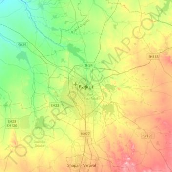
Nome: Mappa topografica Rajkot, altitudine, rilievo.
Luogo: Rajkot, Rajkot East Taluka, Rajkot, Gujarat, 360001, India (22.14533 70.64284 22.46533 70.96284)
Altitudine media: 141 m
Altitudine minima: 65 m
Altitudine massima: 257 m