
Fai una donazione
Equipaggiati per la tua prossima avventura:
In qualità di Affiliato Amazon, questo sito riceve una commissione sugli acquisti idonei, senza costi aggiuntivi per l’utente.
Mappa topografica Placerville
Clicca sulla mappa per visualizzare l'altitudine.
Fai una donazione
Equipaggiati per la tua prossima avventura:
In qualità di Affiliato Amazon, questo sito riceve una commissione sugli acquisti idonei, senza costi aggiuntivi per l’utente.
Placerville
The region east of Placerville, popularly known as Apple Hill and Pleasant Valley, is becoming a center for wine production. The wine region is officially designated as the El Dorado AVA. The largest wineries in the area are Boeger, Lava Cap and Madrona, but most of the 30 plus wineries surrounding Placerville are family owned and smaller in wine grape and wine production. The region is "renown for making vibrantly flavorful, distinctly delicious wines, grown in the dramatic elevations of the Sierra Nevada." The area is increasingly a center for sophisticated production of Rhone style wines, noted by El Dorado County having a local chapter of the Rhone Rangers winemaker association.
Fai una donazione
Equipaggiati per la tua prossima avventura:
In qualità di Affiliato Amazon, questo sito riceve una commissione sugli acquisti idonei, senza costi aggiuntivi per l’utente.
A proposito di questa mappa
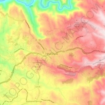
Nome: Mappa topografica Placerville, altitudine, rilievo.
Altitudine media: 586 m
Altitudine minima: 265 m
Altitudine massima: 807 m
Fai una donazione
Equipaggiati per la tua prossima avventura:
In qualità di Affiliato Amazon, questo sito riceve una commissione sugli acquisti idonei, senza costi aggiuntivi per l’utente.
Altre mappe topografiche
Clicca su una mappa per visualizzarne la topografia, l'altitudine e il rilievo.
Pollock Pines
United States > California > El Dorado County > Pollock Pines
Pollock Pines is a census-designated place (CDP) in El Dorado County, California, United States. It is part of the Sacramento–Arden-Arcade–Roseville Metropolitan Statistical Area. Pollock Pines lies at an elevation of 3,980 feet (1,210 m) in the Sierra Nevada. The population was 7,112 at the 2020 census,…
Altitudine media: 1’118 m
Fai una donazione
Equipaggiati per la tua prossima avventura:
In qualità di Affiliato Amazon, questo sito riceve una commissione sugli acquisti idonei, senza costi aggiuntivi per l’utente.
El Dorado Hills
United States > California > El Dorado County > Folsom
El Dorado Hills (EDH), as defined by the 2010 census-designated place (CDP), is at the western border of El Dorado County, between the City of Folsom and the unincorporated community of Cameron Park. The northern limits of the CDP are Folsom Lake and the South Fork of the American River, where river rafters…
Altitudine media: 243 m