
Mappa topografica Burton-on-Trent
Mappa interattiva
Clicca sulla mappa per visualizzare l'altitudine.
A proposito di questa mappa
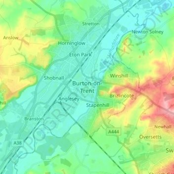
Nome: Mappa topografica Burton-on-Trent, altitudine, rilievo.
Altitudine media: 69 m
Altitudine minima: 38 m
Altitudine massima: 149 m
Burton is about 109 miles (175 km) north west of London, about 30 miles north east of Birmingham, the UK's second largest city and about 23 miles east of the county town Stafford. It is at the easternmost border of the county of Staffordshire with Derbyshire, its suburbs and the course of the River Trent forming part of the county boundary. It is also near the south-eastern terminus of the Trent and Mersey Canal. Burton lies within the northern boundary of the National Forest. The town centre is on the western bank of the River Trent in a valley bottom; its average elevation is about 50 metres above sea level; the village of Winshill and the suburb of Stapenhill rise to 130 m and 100 m respectively.
Altre mappe topografiche
Clicca su una mappa per visualizzarne la topografia, l'altitudine e il rilievo.
Gratwich
United Kingdom > England > Staffordshire > East Staffordshire > Kingstone
Gratwich, Kingstone, East Staffordshire, Staffordshire, England, ST14 8WE, United Kingdom
Altitudine media: 143 m