
Fai una donazione
Equipaggiati per la tua prossima avventura:
In qualità di Affiliato Amazon, questo sito riceve una commissione sugli acquisti idonei, senza costi aggiuntivi per l’utente.
Mappa topografica Yungay
Clicca sulla mappa per visualizzare l'altitudine.
Fai una donazione
Equipaggiati per la tua prossima avventura:
In qualità di Affiliato Amazon, questo sito riceve una commissione sugli acquisti idonei, senza costi aggiuntivi per l’utente.
Yungay
Even though the total area of the commune is around 823 km squared, only 3.87 km squared (0.47% of the total territory) has been urbanized: the cities of Yungay (with 9,288 inhabitants as of 2002) and Campanario. In the 2017 census there were 17,787 total inhabitants in the commune. The Yungay Commune is located on the eastern borders of the region, thus it contains parts of the Cordillera of the Andes, where the altitude reaches between 150 and 2000 meters above sea level. Several rivers flow out of the Andes sector and cross the body of the region. Generally, the land is devoted to agricultural purposes, principally the growth of California Pine, wheat, oats, or lentils; or for livestock grazing.
Fai una donazione
Equipaggiati per la tua prossima avventura:
In qualità di Affiliato Amazon, questo sito riceve una commissione sugli acquisti idonei, senza costi aggiuntivi per l’utente.
A proposito di questa mappa
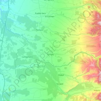
Nome: Mappa topografica Yungay, altitudine, rilievo.
Luogo: Yungay, Provincia de Diguillín, Ñuble Region, Chile (-37.19718 -72.27985 -36.99854 -71.53989)
Altitudine media: 367 m
Altitudine minima: 65 m
Altitudine massima: 1’643 m
Fai una donazione
Equipaggiati per la tua prossima avventura:
In qualità di Affiliato Amazon, questo sito riceve una commissione sugli acquisti idonei, senza costi aggiuntivi per l’utente.
Altre mappe topografiche
Clicca su una mappa per visualizzarne la topografia, l'altitudine e il rilievo.
Fai una donazione
Equipaggiati per la tua prossima avventura:
In qualità di Affiliato Amazon, questo sito riceve una commissione sugli acquisti idonei, senza costi aggiuntivi per l’utente.