
Fai una donazione
Equipaggiati per la tua prossima avventura:
In qualità di Affiliato Amazon, questo sito riceve una commissione sugli acquisti idonei, senza costi aggiuntivi per l’utente.
Mappa topografica Alhambra
Clicca sulla mappa per visualizzare l'altitudine.
Fai una donazione
Equipaggiati per la tua prossima avventura:
In qualità di Affiliato Amazon, questo sito riceve una commissione sugli acquisti idonei, senza costi aggiuntivi per l’utente.
Alhambra
During the reign of the Nasrid Dynasty, the Alhambra was transformed into a palatine city, complete with an irrigation system composed of aqueducts and water channels that provided water for the complex and for other nearby countryside palaces such as the Generalife. Previously, the old fortresses on the hill had been dependent on rainwater collected from the cistern near the Alcazaba and on what could be brought up from the Darro River below. The creation of the Sultan's Canal (Arabic: ساقلتة السلطان, romanized: Saqiyat al-Sultan), which brought water from the mountains to the east, solidified the identity of the Alhambra as a palace-city rather than a defensive and ascetic structure. This first hydraulic system was expanded afterwards and included two long water channels and several sophisticated elevation devices to bring water onto the plateau.
Fai una donazione
Equipaggiati per la tua prossima avventura:
In qualità di Affiliato Amazon, questo sito riceve una commissione sugli acquisti idonei, senza costi aggiuntivi per l’utente.
A proposito di questa mappa
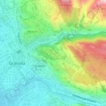
Nome: Mappa topografica Alhambra, altitudine, rilievo.
Altitudine media: 759 m
Altitudine minima: 659 m
Altitudine massima: 971 m
Fai una donazione
Equipaggiati per la tua prossima avventura:
In qualità di Affiliato Amazon, questo sito riceve una commissione sugli acquisti idonei, senza costi aggiuntivi per l’utente.