Mappa topografica Ormskirk
Mappa interattiva
Clicca sulla mappa per visualizzare l'altitudine.
A proposito di questa mappa
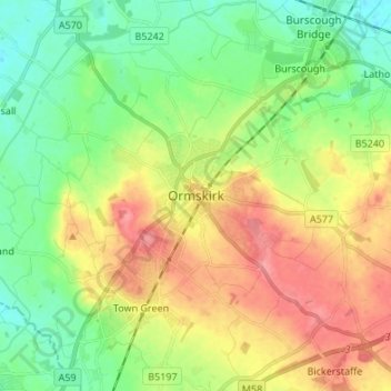
Altre mappe topografiche
Clicca su una mappa per visualizzarne la topografia, l'altitudine e il rilievo.
Becconsall
United Kingdom > England > Lancashire > West Lancashire
Becconsall, West Lancashire, Lancashire, England, PR4 6SN, United Kingdom
Altitudine media: 10 m
Skelmersdale
United Kingdom > England > Lancashire > West Lancashire
Skelmersdale, West Lancashire, Lancashire, England, United Kingdom
Altitudine media: 76 m
Newburgh
United Kingdom > England > Lancashire > West Lancashire > Newburgh
Newburgh, West Lancashire, Lancashire, England, United Kingdom
Altitudine media: 37 m
Skelmersdale
United Kingdom > England > Lancashire > West Lancashire
Skelmersdale, West Lancashire, Lancashire, England, WN8 6ES, United Kingdom
Altitudine media: 68 m
Scarisbrick
United Kingdom > England > Lancashire > West Lancashire > Scarisbrick
Scarisbrick, West Lancashire, Lancashire, England, United Kingdom
Altitudine media: 12 m
Holt Green
United Kingdom > England > Lancashire > West Lancashire > Aughton > Holt Green
Holt Green, Aughton, West Lancashire, Lancashire, England, L39 6SL, United Kingdom
Altitudine media: 35 m
Burscough
United Kingdom > England > Lancashire > West Lancashire
Burscough, West Lancashire, Lancashire, England, United Kingdom
Altitudine media: 14 m
Tarleton
United Kingdom > England > Lancashire > West Lancashire
Tarleton, West Lancashire, Lancashire, England, United Kingdom
Altitudine media: 8 m
Dalton
United Kingdom > England > Lancashire > West Lancashire > Dalton
Dalton, West Lancashire, Lancashire, North West England, England, United Kingdom
Altitudine media: 77 m
Bury Hey Wood
United Kingdom > England > Lancashire > West Lancashire > Appley Bridge > Robin Hood
Bury Hey Wood, Robin Hood, Wrightington, Appley Bridge, West Lancashire, Lancashire, England, United Kingdom
Altitudine media: 106 m
Aughton
United Kingdom > England > Lancashire > West Lancashire > Town Green
Aughton, Town Green, West Lancashire, Lancashire, England, United Kingdom
Altitudine media: 39 m
Up Holland
United Kingdom > England > Lancashire > West Lancashire > Upholland
Up Holland, Upholland, West Lancashire, Lancashire, England, United Kingdom
Altitudine media: 89 m
North Meols
United Kingdom > England > Lancashire > West Lancashire > Banks
North Meols, Banks, West Lancashire, Lancashire, North West England, England, United Kingdom
Altitudine media: 5 m
Parbold
United Kingdom > England > Lancashire > West Lancashire > Parbold
Parbold, West Lancashire, Lancashire, England, United Kingdom
Altitudine media: 62 m
Bickerstaffe
United Kingdom > England > Lancashire > West Lancashire > Bickerstaffe
Bickerstaffe, West Lancashire, Lancashire, England, United Kingdom
Altitudine media: 51 m
Tontine
United Kingdom > England > Lancashire > West Lancashire > Upholland > Tontine
Tontine, Up Holland, Upholland, West Lancashire, Lancashire, North West England, England, WN5 8UJ, United Kingdom
Altitudine media: 101 m
Lathom
United Kingdom > England > Lancashire > West Lancashire
Lathom, West Lancashire, Lancashire, England, United Kingdom
Altitudine media: 26 m
Rufford
United Kingdom > England > Lancashire > West Lancashire
Rufford, West Lancashire, Lancashire, England, United Kingdom
Altitudine media: 8 m
Wrightington
United Kingdom > England > Lancashire > West Lancashire
Wrightington, West Lancashire, Lancashire, England, United Kingdom
Altitudine media: 80 m
Simonswood
United Kingdom > England > Lancashire > West Lancashire
Simonswood, West Lancashire, Lancashire, England, L33 4XX, United Kingdom
Altitudine media: 36 m
Mere Brow
United Kingdom > England > Lancashire > West Lancashire
Mere Brow, West Lancashire, Lancashire, England, PR4 6JY, United Kingdom
Altitudine media: 7 m