Geolocalizza

Mappa topografica Barton-under-Needwood

Clicca sulla mappa per visualizzare l'altitudine.

A proposito di questa mappa

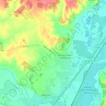
Nome: Mappa topografica Barton-under-Needwood, altitudine, rilievo.

Luogo: Barton-under-Needwood, East Staffordshire, Staffordshire, England, United Kingdom (52.74096 -1.77929 52.79127 -1.68253)

Altitudine media: 69 m

Altitudine minima: 42 m

Altitudine massima: 126 m

Altre mappe topografiche

Clicca su una mappa per visualizzarne la topografia, l'altitudine e il rilievo.

Burton upon Trent

United Kingdom > England > Staffordshire > East Staffordshire

Burton is about 109 miles (175 km) north west of London, about 30 miles north east of Birmingham, the UK's second largest city and about 23 miles east of the county town Stafford. It is at the easternmost border of the county of Staffordshire with Derbyshire, its suburbs and the course of the River Trent…

Altitudine media: 69 m

Equipaggiati per la tua prossima avventura:

🧭Bussola da Escursionismo - Bussola precisa per orientamento in natura
🎒Sacca Compressione - Per ridurre volume dell’equipaggiamento
🛠️Multitool per Bici - Attrezzo tascabile per riparazioni rapide lungo il percorso
🧦Calze Termiche - Calze tecniche per escursioni invernali
🔦Set Luci Bici LED - Illuminazione ad alta visibilità per tratti stradali e gallerie

In qualità di Affiliato Amazon, questo sito riceve una commissione sugli acquisti idonei, senza costi aggiuntivi per l’utente.