
Mappa topografica Preiss Heights
Clicca sulla mappa per visualizzare l'altitudine.
A proposito di questa mappa
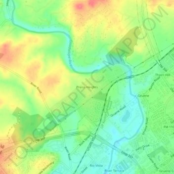
Nome: Mappa topografica Preiss Heights, altitudine, rilievo.
Luogo: Preiss Heights, Comal County, Texas, 78135, United States (29.72050 -98.13918 29.76050 -98.09918)
Altitudine media: 214 m
Altitudine minima: 185 m
Altitudine massima: 251 m
Altre mappe topografiche
Clicca su una mappa per visualizzarne la topografia, l'altitudine e il rilievo.
New Braunfels
United States > Texas > Comal County
New Braunfels occupies a transitional Hill Country setting on the Balcones Escarpment, where the higher, more dissected limestone uplands of the Edwards Plateau give way southeastward toward lower prairie terrain. The city’s relief is organized around the Guadalupe River valley and the short spring-fed Comal…
Altitudine media: 228 m
Comal River
United States > Texas > Comal County > New Braunfels > Landa Park Estates
Altitudine media: 206 m
New Braunfels
United States > Texas > Comal County
New Braunfels occupies a transitional Hill Country setting on the Balcones Escarpment, where the higher, more dissected limestone uplands of the Edwards Plateau give way southeastward toward lower prairie terrain. The city’s relief is organized around the Guadalupe River valley and the short spring-fed Comal…
Altitudine media: 228 m