
Mappa topografica Burlington
Mappa interattiva
Clicca sulla mappa per visualizzare l'altitudine.
A proposito di questa mappa
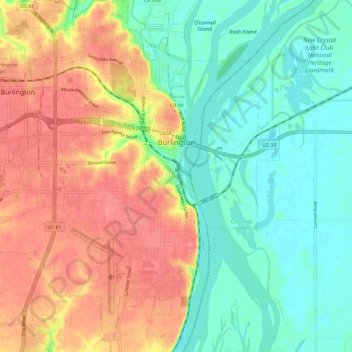
Nome: Mappa topografica Burlington, altitudine, rilievo.
Luogo: Burlington, Des Moines County, Iowa, 52601, United States (40.76095 -91.18026 40.84766 -91.07838)
Altitudine media: 183 m
Altitudine minima: 154 m
Altitudine massima: 219 m
Burlington hosts the Snake Alley Criterium, one of the most physically challenging races in the Midwest. The annual event is held on a 15-block course, with differences in elevation from 555 feet to 678 feet. The course is entirely on city streets, mostly in the downtown commercial area. A one-block-long climb is on the historic brick street named Snake Alley. The 276-foot-long Snake Alley has five switchbacks in a 60-foot climb. The average grade is 12.5 percent in that one block.