
Mappa topografica Cranleigh
Mappa interattiva
Clicca sulla mappa per visualizzare l'altitudine.
A proposito di questa mappa
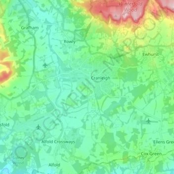
Nome: Mappa topografica Cranleigh, altitudine, rilievo.
Altitudine media: 78 m
Altitudine minima: 24 m
Altitudine massima: 257 m
Elevations range from a maximum of 240 m AOD (mean high water level) at the car park on Reynolds Hill in Winterfold Heath (a woodland in the north) to 41 m on the watercourse and the disused Wey and Arun Canal as they leave both the parish in the northwest extreme at the end of East Whipley Lane. The village centre lies at generally 50–70 m above AOD.