
Fai una donazione
Equipaggiati per la tua prossima avventura:
In qualità di Affiliato Amazon, questo sito riceve una commissione sugli acquisti idonei, senza costi aggiuntivi per l’utente.
Mappa topografica Sherborne St John
Clicca sulla mappa per visualizzare l'altitudine.
Fai una donazione
Equipaggiati per la tua prossima avventura:
In qualità di Affiliato Amazon, questo sito riceve una commissione sugli acquisti idonei, senza costi aggiuntivi per l’utente.
A proposito di questa mappa
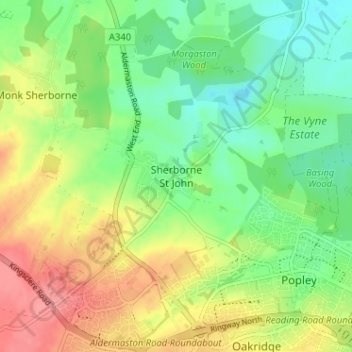
Nome: Mappa topografica Sherborne St John, altitudine, rilievo.
Altitudine media: 92 m
Altitudine minima: 58 m
Altitudine massima: 138 m
Fai una donazione
Equipaggiati per la tua prossima avventura:
In qualità di Affiliato Amazon, questo sito riceve una commissione sugli acquisti idonei, senza costi aggiuntivi per l’utente.
Altre mappe topografiche
Clicca su una mappa per visualizzarne la topografia, l'altitudine e il rilievo.
Newtown
United Kingdom > England > Hampshire > Basingstoke and Deane > Newtown
Altitudine media: 109 m
Winterhill Plantation
United Kingdom > England > Hampshire > Basingstoke and Deane > Whitchurch > Wells-In-The-Field
Altitudine media: 100 m
Fai una donazione
Equipaggiati per la tua prossima avventura:
In qualità di Affiliato Amazon, questo sito riceve una commissione sugli acquisti idonei, senza costi aggiuntivi per l’utente.
Basingstoke
United Kingdom > England > Hampshire > Basingstoke and Deane
Situated in a valley through the Hampshire Downs at an average elevation of 88 metres (289 ft) Basingstoke is a major interchange between Reading, Newbury, Andover, Winchester, and Alton, and lies on the natural trade route between the southwest of England and London. The area had been something of an…
Altitudine media: 109 m
Morgaston Wood
United Kingdom > England > Hampshire > Basingstoke and Deane > Sherborne St John
Altitudine media: 76 m
Fai una donazione
Equipaggiati per la tua prossima avventura:
In qualità di Affiliato Amazon, questo sito riceve una commissione sugli acquisti idonei, senza costi aggiuntivi per l’utente.
Mortimer West End
United Kingdom > England > Hampshire > Basingstoke and Deane > Mortimer West End
Altitudine media: 90 m
Fai una donazione
Equipaggiati per la tua prossima avventura:
In qualità di Affiliato Amazon, questo sito riceve una commissione sugli acquisti idonei, senza costi aggiuntivi per l’utente.
Wootton St. Lawrence
United Kingdom > England > Hampshire > Basingstoke and Deane
Altitudine media: 115 m
Sherborne St. John
United Kingdom > England > Hampshire > Basingstoke and Deane > Sherborne St John
Altitudine media: 79 m
Fai una donazione
Equipaggiati per la tua prossima avventura:
In qualità di Affiliato Amazon, questo sito riceve una commissione sugli acquisti idonei, senza costi aggiuntivi per l’utente.
Bramley Corner
United Kingdom > England > Hampshire > Basingstoke and Deane > Bramley
Altitudine media: 69 m
Fai una donazione
Equipaggiati per la tua prossima avventura:
In qualità di Affiliato Amazon, questo sito riceve una commissione sugli acquisti idonei, senza costi aggiuntivi per l’utente.
Sherfield on Loddon
United Kingdom > England > Hampshire > Basingstoke and Deane
Altitudine media: 66 m
Monk Sherborne
United Kingdom > England > Hampshire > Basingstoke and Deane > Monk Sherborne
Altitudine media: 107 m
Fai una donazione
Equipaggiati per la tua prossima avventura:
In qualità di Affiliato Amazon, questo sito riceve una commissione sugli acquisti idonei, senza costi aggiuntivi per l’utente.
Kingsclere
United Kingdom > England > Hampshire > Basingstoke and Deane > Kingsclere
Altitudine media: 139 m
Chineham
United Kingdom > England > Hampshire > Basingstoke and Deane > Basingstoke
Altitudine media: 78 m
Fai una donazione
Equipaggiati per la tua prossima avventura:
In qualità di Affiliato Amazon, questo sito riceve una commissione sugli acquisti idonei, senza costi aggiuntivi per l’utente.
River Lyde
United Kingdom > England > Hampshire > Basingstoke and Deane > Up Nately
Altitudine media: 78 m
Baughurst
United Kingdom > England > Hampshire > Basingstoke and Deane > Wolverton Townsend
Altitudine media: 106 m
Fai una donazione
Equipaggiati per la tua prossima avventura:
In qualità di Affiliato Amazon, questo sito riceve una commissione sugli acquisti idonei, senza costi aggiuntivi per l’utente.
St. Mary Bourne
United Kingdom > England > Hampshire > Basingstoke and Deane > Stoke
Altitudine media: 125 m
Fai una donazione
Equipaggiati per la tua prossima avventura:
In qualità di Affiliato Amazon, questo sito riceve una commissione sugli acquisti idonei, senza costi aggiuntivi per l’utente.
East Woodhay
United Kingdom > England > Hampshire > Basingstoke and Deane > East End
Altitudine media: 171 m
Fai una donazione
Equipaggiati per la tua prossima avventura:
In qualità di Affiliato Amazon, questo sito riceve una commissione sugli acquisti idonei, senza costi aggiuntivi per l’utente.
Highclere
United Kingdom > England > Hampshire > Basingstoke and Deane > Highclere
Altitudine media: 154 m
Highclere
United Kingdom > England > Hampshire > Basingstoke and Deane > Highclere
Altitudine media: 154 m
Fai una donazione
Equipaggiati per la tua prossima avventura:
In qualità di Affiliato Amazon, questo sito riceve una commissione sugli acquisti idonei, senza costi aggiuntivi per l’utente.
Chineham
United Kingdom > England > Hampshire > Basingstoke and Deane > Basingstoke
Altitudine media: 78 m
Fai una donazione
Equipaggiati per la tua prossima avventura:
In qualità di Affiliato Amazon, questo sito riceve una commissione sugli acquisti idonei, senza costi aggiuntivi per l’utente.