
Mappa topografica Royston
Clicca sulla mappa per visualizzare l'altitudine.
A proposito di questa mappa
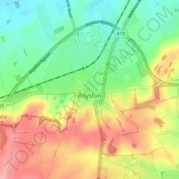
Nome: Mappa topografica Royston, altitudine, rilievo.
Altitudine media: 78 m
Altitudine minima: 32 m
Altitudine massima: 137 m
Altre mappe topografiche
Clicca su una mappa per visualizzarne la topografia, l'altitudine e il rilievo.
Letchworth
United Kingdom > England > Hertfordshire > North Hertfordshire > Letchworth
Altitudine media: 80 m
Ashbrook
United Kingdom > England > Hertfordshire > North Hertfordshire > St Ippolyts
Altitudine media: 85 m
Windmill Hill
United Kingdom > England > Hertfordshire > North Hertfordshire > Hitchin
Altitudine media: 74 m
Temple Dinsley
United Kingdom > England > Hertfordshire > North Hertfordshire > Preston
Altitudine media: 124 m
Bendish
United Kingdom > England > Hertfordshire > North Hertfordshire > Breachwood Green
Altitudine media: 128 m
Knebworth Country Park
United Kingdom > England > Hertfordshire > North Hertfordshire > Knebworth
Altitudine media: 116 m
Peter's Green
United Kingdom > England > Hertfordshire > North Hertfordshire > Kimpton
Altitudine media: 133 m
Redcoats Green
United Kingdom > England > Hertfordshire > North Hertfordshire > Little Wymondley
Altitudine media: 95 m
Cockernhoe
United Kingdom > England > Hertfordshire > North Hertfordshire > Offley > Cockernhoe
Altitudine media: 149 m
Little Wymondley
United Kingdom > England > Hertfordshire > North Hertfordshire
Altitudine media: 92 m
Offley Hoo
United Kingdom > England > Hertfordshire > North Hertfordshire > Offley
Altitudine media: 134 m
Ivel Springs Local Nature Reserve
United Kingdom > England > Hertfordshire > North Hertfordshire > Baldock
Altitudine media: 72 m
Long Pond
United Kingdom > England > Hertfordshire > North Hertfordshire > Offley > Offley Hoo
Altitudine media: 142 m
Knebworth Country Park
United Kingdom > England > Hertfordshire > North Hertfordshire > Knebworth
Altitudine media: 116 m