
Mappa topografica Newark
Mappa interattiva
Clicca sulla mappa per visualizzare l'altitudine.
A proposito di questa mappa
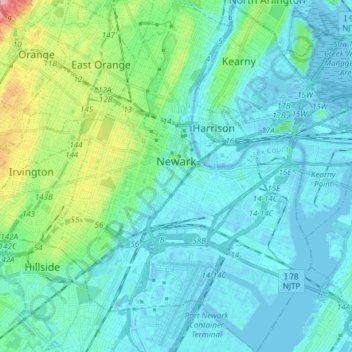
Nome: Mappa topografica Newark, altitudine, rilievo.
Luogo: Newark, Essex County, New Jersey, United States (40.67325 -74.25133 40.78814 -74.11418)
Altitudine media: 22 m
Altitudine minima: -11 m
Altitudine massima: 131 m
According to the United States Census Bureau, the city had a total area of 25.89 square miles (67.1 km2), including 24.14 square miles (62.5 km2) of land and 1.74 square miles (4.5 km2) of water (6.72%). It has the third-smallest land area among the 100 most populous cities in the U.S., behind neighboring Jersey City and Hialeah, Florida. The city's altitude ranges from 0 (sea level) in the east to approximately 230 feet (70 m) above sea level in the western section of the city. Newark is essentially a large basin sloping towards the Passaic River, with a few valleys formed by meandering streams. Historically, Newark's high places have been its wealthier neighborhoods. In the 19th century and early 20th century, the wealthy congregated on the ridges of Forest Hill, High Street, and Weequahic.
Altre mappe topografiche
Clicca su una mappa per visualizzarne la topografia, l'altitudine e il rilievo.
Millburn
United States > New Jersey > Essex County
Millburn, Essex County, New Jersey, United States
Altitudine media: 88 m
Glen Ridge
United States > New Jersey > Essex County > Glen Ridge
Glen Ridge, Essex County, New Jersey, 07028, United States
Altitudine media: 71 m
West Caldwell
United States > New Jersey > Essex County
West Caldwell, Essex County, New Jersey, 07006, United States
Altitudine media: 76 m
Short Hills
United States > New Jersey > Essex County > Short Hills
Short Hills, Millburn, Essex County, New Jersey, 07078, United States
Altitudine media: 98 m