
Mappa topografica Aurora
Mappa interattiva
Clicca sulla mappa per visualizzare l'altitudine.
Aurora
Aurora's official elevation, posted on signs at the city limits, is 5,471 feet (1,668 m). However, the city spans a difference in elevation of nearly 1,000 feet (300 m). The lowest elevation of 5,285 feet (1,611 m) is found at the point where Sand Creek crosses the city limit in the northwest corner of the city, while the highest elevation of 6,229 feet (1,899 m) is on the extreme southern border of the city in Douglas County, near the intersection of Inspiration and Gartrell roads.[20]
A proposito di questa mappa
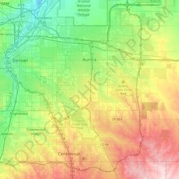
Nome: Mappa topografica Aurora, altitudine, rilievo.
Luogo: Aurora, Adams County, Colorado, United States (39.55106 -104.88654 39.82697 -104.48891)
Altitudine media: 1’691 m
Altitudine minima: 1’548 m
Altitudine massima: 1’930 m