
Fai una donazione
Equipaggiati per la tua prossima avventura:
In qualità di Affiliato Amazon, questo sito riceve una commissione sugli acquisti idonei, senza costi aggiuntivi per l’utente.
Mappa topografica Alyth
Clicca sulla mappa per visualizzare l'altitudine.
Fai una donazione
Equipaggiati per la tua prossima avventura:
In qualità di Affiliato Amazon, questo sito riceve una commissione sugli acquisti idonei, senza costi aggiuntivi per l’utente.
Alyth
To the northeast of the town a hill fort, possibly of Pictish date or earlier, stands atop Barry (or 'barrow') Hill. It is considered to be one of the best preserved examples of an enclosed hilltop settlement in Scotland. The remains consist of massive collapsed stone ramparts that take advantage of the topography of the Hill. Local legend connects the fort with King Arthur, and Hector Boece's History and Chronicles of Scotland claims that Guanora, the Scottish name for Guinevere, Arthur's queen, was imprisoned here for a very short time(page 86).
Fai una donazione
Equipaggiati per la tua prossima avventura:
In qualità di Affiliato Amazon, questo sito riceve una commissione sugli acquisti idonei, senza costi aggiuntivi per l’utente.
A proposito di questa mappa
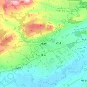
Nome: Mappa topografica Alyth, altitudine, rilievo.
Luogo: Alyth, Perth and Kinross, Scotland, PH11 8AH, United Kingdom (56.58255 -3.27026 56.66255 -3.19026)
Altitudine media: 125 m
Altitudine minima: 34 m
Altitudine massima: 373 m
Fai una donazione
Equipaggiati per la tua prossima avventura:
In qualità di Affiliato Amazon, questo sito riceve una commissione sugli acquisti idonei, senza costi aggiuntivi per l’utente.
Altre mappe topografiche
Clicca su una mappa per visualizzarne la topografia, l'altitudine e il rilievo.
Loch Tay
United Kingdom > Scotland > Perth and Kinross > Kenmore
In the Early Medieval period people began to cultivate the higher elevations of the hills around the loch. The Macnabs, the Menzies, the Drummonds, the Napiers, the Haldanes, the MacGregors and the Robertsons of Carwhin and Strowan all owned land around the loch but little remains of their possible…
Altitudine media: 460 m
Fai una donazione
Equipaggiati per la tua prossima avventura:
In qualità di Affiliato Amazon, questo sito riceve una commissione sugli acquisti idonei, senza costi aggiuntivi per l’utente.
Dupplin Castle
United Kingdom > Scotland > Perth and Kinross > Forteviot > Aberdalgie
Altitudine media: 74 m
Fai una donazione
Equipaggiati per la tua prossima avventura:
In qualità di Affiliato Amazon, questo sito riceve una commissione sugli acquisti idonei, senza costi aggiuntivi per l’utente.
Glen Shee
United Kingdom > Scotland > Perth and Kinross > Spittal of Glenshee
The A93 road, part of General Wade's military road from Perth to Fort George, runs north through the glen and on into Glen Beag, where it crosses the Cairnwell Pass, which at an elevation of 2,200 feet (670 metres) is the highest public road in the UK. The road climbing to the summit is now wide and straight…
Altitudine media: 387 m
Fai una donazione
Equipaggiati per la tua prossima avventura:
In qualità di Affiliato Amazon, questo sito riceve una commissione sugli acquisti idonei, senza costi aggiuntivi per l’utente.
Loch Leven National Nature Reserve
United Kingdom > Scotland > Perth and Kinross > Kinross
Altitudine media: 119 m
The Birks of Aberfeldy
United Kingdom > Scotland > Perth and Kinross > Aberfeldy
Altitudine media: 222 m
Fai una donazione
Equipaggiati per la tua prossima avventura:
In qualità di Affiliato Amazon, questo sito riceve una commissione sugli acquisti idonei, senza costi aggiuntivi per l’utente.
Fai una donazione
Equipaggiati per la tua prossima avventura:
In qualità di Affiliato Amazon, questo sito riceve una commissione sugli acquisti idonei, senza costi aggiuntivi per l’utente.
Fai una donazione
Equipaggiati per la tua prossima avventura:
In qualità di Affiliato Amazon, questo sito riceve una commissione sugli acquisti idonei, senza costi aggiuntivi per l’utente.
Fai una donazione
Equipaggiati per la tua prossima avventura:
In qualità di Affiliato Amazon, questo sito riceve una commissione sugli acquisti idonei, senza costi aggiuntivi per l’utente.
Loch Monzievaird
United Kingdom > Scotland > Perth and Kinross > Crieff > Monzievaird
Altitudine media: 121 m
Fai una donazione
Equipaggiati per la tua prossima avventura:
In qualità di Affiliato Amazon, questo sito riceve una commissione sugli acquisti idonei, senza costi aggiuntivi per l’utente.
Loch Errochty
United Kingdom > Scotland > Perth and Kinross
Loch Errochty is a man made freshwater loch situated within the Perth and Kinross council area at the edge of the Scottish Highlands near the Highland Boundary Fault where the topography changes to lowland.
Altitudine media: 457 m
Fai una donazione
Equipaggiati per la tua prossima avventura:
In qualità di Affiliato Amazon, questo sito riceve una commissione sugli acquisti idonei, senza costi aggiuntivi per l’utente.