
Fai una donazione
Equipaggiati per la tua prossima avventura:
In qualità di Affiliato Amazon, questo sito riceve una commissione sugli acquisti idonei, senza costi aggiuntivi per l’utente.
Mappa topografica Greeley
Clicca sulla mappa per visualizzare l'altitudine.
Fai una donazione
Equipaggiati per la tua prossima avventura:
In qualità di Affiliato Amazon, questo sito riceve una commissione sugli acquisti idonei, senza costi aggiuntivi per l’utente.
Greeley
Greeley experiences a semi-arid climate (Köppen BSk). High temperatures are generally around 90–95 °F (32 °C) in the summer and 40-45 °F (4 °C) in the winter, although significant variation occurs. The hottest days generally occur around the third week of July and the coldest in January. Nighttime lows are near 60 °F (16 °C) in the summer and around 15–20 °F (−9 °C) in the winter. Record high temperatures of 112 °F (44.4 °C) have been recorded, as have record low temperatures of –25 °F (–32 °C). The first freeze typically occurs around October 4 and the last around May 4. Extratropical cyclones which disrupt the weather for the eastern two-thirds of the US often originate in or near Colorado, which means Greeley does not experience many fully developed storm systems. Warm fronts, sleet, and freezing rain are practically nonexistent here. In addition, the city's proximity to the Rocky Mountains and lower elevation, compared to the mountains west of the city, result in less precipitation and fewer thunderstorms. This is paradoxical, because adjacent areas (mostly farmland) experience between 7 and 9 hail days per year.
Fai una donazione
Equipaggiati per la tua prossima avventura:
In qualità di Affiliato Amazon, questo sito riceve una commissione sugli acquisti idonei, senza costi aggiuntivi per l’utente.
A proposito di questa mappa
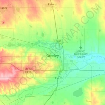
Nome: Mappa topografica Greeley, altitudine, rilievo.
Luogo: Greeley, Weld County, Colorado, United States (40.37757 -104.90739 40.48122 -104.61914)
Altitudine media: 1’448 m
Altitudine minima: 1’398 m
Altitudine massima: 1’543 m
Fai una donazione
Equipaggiati per la tua prossima avventura:
In qualità di Affiliato Amazon, questo sito riceve una commissione sugli acquisti idonei, senza costi aggiuntivi per l’utente.
Altre mappe topografiche
Clicca su una mappa per visualizzarne la topografia, l'altitudine e il rilievo.
Saint Vrain State Park
United States > Colorado > Weld County > Firestone
The land of St. Vrain State Park was originally home to Ute, Arapaho, and Cheyenne Native American tribes. Once claimed by Spain then France who sold it to the United States in 1803 as part of the Louisiana Purchase. Having just made the largest land purchase in the history of the nation, the government was…
Altitudine media: 1’480 m
Fai una donazione
Equipaggiati per la tua prossima avventura:
In qualità di Affiliato Amazon, questo sito riceve una commissione sugli acquisti idonei, senza costi aggiuntivi per l’utente.
Windsor
United States > Colorado > Weld County > Windsor > Windsor
Some days in the winter and spring can be warm and extremely dry, with Chinook winds often raising temperatures to near 70 °F (21 °C) in January and February, and sometimes to near 90 °F (32 °C) in April. Windsor's elevation and low year-round humidity means that nighttime low temperatures are practically…
Altitudine media: 1’471 m