
Mappa topografica Saint Catherine
Mappa interattiva
Clicca sulla mappa per visualizzare l'altitudine.
A proposito di questa mappa
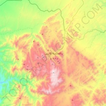
Nome: Mappa topografica Saint Catherine, altitudine, rilievo.
Luogo: Saint Catherine, Shibh Jazirat Sina', Egypt (28.40751 33.79356 28.72751 34.11356)
Altitudine media: 1’472 m
Altitudine minima: 520 m
Altitudine massima: 2’629 m
Köppen-Geiger climate classification system classifies the climate as desert (BWh). Saint Catherine has the coldest nights of any city in Egypt, and its humidity is very low. The highest mountain ranges in Egypt surround the town, with many smaller valleys leading from the basin to the mountains in all directions. The township is at an elevation of 1,600 metres (5,200 ft). The high altitude of the town and the high mountain ranges which surround it provide a pleasant climate with mild summer nights and relatively cool winter days. The nights can get very cold on rare occasions, making it sometimes necessary to heat buildings and public places. Saint Catherine is considered to be one of the coldest towns in Egypt along with Nekhel and other locales in mountainous Sinai. Saint Catherine receives infrequent snowfalls during December, January, and February, however, snow has also occurred in late autumn and early spring.
Altre mappe topografiche
Clicca su una mappa per visualizzarne la topografia, l'altitudine e il rilievo.
Ras Muhammad
Ras Muhammad, Shibh Jazirat Sina', Egypt
Altitudine media: 3 m
Sharm Ash Sheikh
Sharm Ash Sheikh, Ras Umm Sid, South Sinai, 46619, Egypt
Altitudine media: 135 m