
Fai una donazione
Equipaggiati per la tua prossima avventura:
In qualità di Affiliato Amazon, questo sito riceve una commissione sugli acquisti idonei, senza costi aggiuntivi per l’utente.
Mappa topografica Lakeville
Clicca sulla mappa per visualizzare l'altitudine.
Fai una donazione
Equipaggiati per la tua prossima avventura:
In qualità di Affiliato Amazon, questo sito riceve una commissione sugli acquisti idonei, senza costi aggiuntivi per l’utente.
A proposito di questa mappa
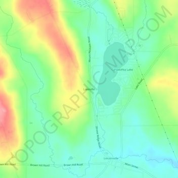
Nome: Mappa topografica Lakeville, altitudine, rilievo.
Altitudine media: 447 m
Altitudine minima: 407 m
Altitudine massima: 518 m
Fai una donazione
Equipaggiati per la tua prossima avventura:
In qualità di Affiliato Amazon, questo sito riceve una commissione sugli acquisti idonei, senza costi aggiuntivi per l’utente.
Altre mappe topografiche
Clicca su una mappa per visualizzarne la topografia, l'altitudine e il rilievo.
Pymatuning State Park
United States > Pennsylvania > Crawford County > North Shenango Township
Altitudine media: 331 m
Fredericksburg
United States > Pennsylvania > Crawford County > Vernon Township
Altitudine media: 370 m
Titusville
United States > Pennsylvania > Crawford County
The City of Titusville is located in the southeastern Corner of Crawford County in the Pittsburgh High Plateau. The city is drained by Oil Creek, a south-flowing tributary of the Allegheny River, and two tributaries to Oil Creek, Pine Creek, and Church Run. The lowest elevation in the City of Titusville is…
Altitudine media: 419 m
Fai una donazione
Equipaggiati per la tua prossima avventura:
In qualità di Affiliato Amazon, questo sito riceve una commissione sugli acquisti idonei, senza costi aggiuntivi per l’utente.
Spartansburg
United States > Pennsylvania > Crawford County
Spartansburg Borough is located on the glaciated plateau of northwestern Pennsylvania. The borough is drained by East Branch Oil Creek, which begins at the outlet of Clear Lake, an impoundment of Patrick Run and Stranahan Run. The lowest elevation in Spartansburg is 1,430 ft (440 m) where East Branch Oil Creek…
Altitudine media: 463 m
Fai una donazione
Equipaggiati per la tua prossima avventura:
In qualità di Affiliato Amazon, questo sito riceve una commissione sugli acquisti idonei, senza costi aggiuntivi per l’utente.
Townville
United States > Pennsylvania > Crawford County
The borough is in a valley at the height of land between north-flowing Muddy Creek and south-flowing Sugar Creek, both tributaries of French Creek and part of the Allegheny River watershed. The lowest elevation in Townville is 1,370 ft (420 m) on the southern boundary at the wetland that is drained by Muddy…
Altitudine media: 450 m
Athens Township
United States > Pennsylvania > Crawford County
Geologic Province: Northwestern Glaciated Plateau Lowest Elevation: 1,180 ft (360 m) where Muddy Creek flows out of the township. Highest Elevation: 1,650 ft (500 m) east of Grange Hall Road Major Rivers/Streams and Watersheds: Oil Creek and Muddy Creek Minor Rivers/Streams and Watersheds: Muddy Creek…
Altitudine media: 432 m
Fai una donazione
Equipaggiati per la tua prossima avventura:
In qualità di Affiliato Amazon, questo sito riceve una commissione sugli acquisti idonei, senza costi aggiuntivi per l’utente.
Titusville
United States > Pennsylvania > Crawford County
The City of Titusville is located in the southeastern Corner of Crawford County in the Pittsburgh High Plateau. The city is drained by Oil Creek, a south-flowing tributary of the Allegheny River, and two tributaries to Oil Creek, Pine Creek, and Church Run. The lowest elevation in the City of Titusville is…
Altitudine media: 419 m
Spartansburg
United States > Pennsylvania > Crawford County > Spartansburg
Spartansburg Borough is located on the glaciated plateau of northwestern Pennsylvania. The borough is drained by East Branch Oil Creek, which begins at the outlet of Clear Lake, an impoundment of Patrick Run and Stranahan Run. The lowest elevation in Spartansburg is 1,430 ft (440 m) where East Branch Oil Creek…
Altitudine media: 463 m
Rome Township
United States > Pennsylvania > Crawford County
Rome Township is located in the southeastern part of Crawford County in the Northwestern Glaciated Plateau of Pennsylvania. The township is drained by Oil Creek, a southward-flowing tributary of the Allegheny River, and two tributaries to Oil Creek, East Branch Oil Creek, and tributaries of Thompson Creek.…
Altitudine media: 472 m
Fai una donazione
Equipaggiati per la tua prossima avventura:
In qualità di Affiliato Amazon, questo sito riceve una commissione sugli acquisti idonei, senza costi aggiuntivi per l’utente.