
Mappa topografica Timișoara
Mappa interattiva
Clicca sulla mappa per visualizzare l'altitudine.
A proposito di questa mappa
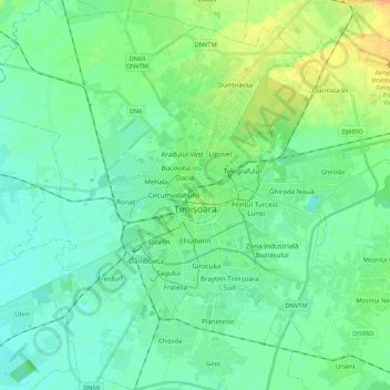
Nome: Mappa topografica Timișoara, altitudine, rilievo.
Luogo: Timișoara, Timiș, Romania (45.68383 21.11168 45.83417 21.32717)
Altitudine media: 92 m
Altitudine minima: 83 m
Altitudine massima: 113 m
Timișoara lies at an altitude of 90 metres on the southeast edge of the Banat Plain, part of the Pannonian Plain, near the divergence of the Timiș and Bega rivers. The waters of the two rivers form a swampy and frequently flooded land. Timișoara developed on one of few places where the swamps could be crossed. These constituted a natural protection around the fortress for a very long time and favored a wet and insalubrious climate, which spread plague and cholera and kept the number of inhabitants relatively low, preventing civic development. With time, these rivers were drained, dammed and diverted. Due to the hydrographical projects undertaken in the 18th century, the city no longer lies on the Timiș River, but on the Bega Canal. This improvement of the land was made irreversible by building the Bega Canal (started in 1728) and by the complete draining of the surrounding marshes. The city lies only 0.5 to 5 metres above the water table, which disallows the construction of tall buildings. The rich black soil and relatively high water table make this a fertile agricultural region.
Altre mappe topografiche
Clicca su una mappa per visualizzarne la topografia, l'altitudine e il rilievo.
Teremia Mică
Romania > Timiș > Teremia Mică
Teremia Mică, Timiș, 307407, Romania
Altitudine media: 80 m