
Mappa topografica Leeds and the Thousand Islands
Mappa interattiva
Clicca sulla mappa per visualizzare l'altitudine.
A proposito di questa mappa
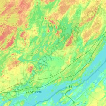
Nome: Mappa topografica Leeds and the Thousand Islands, altitudine, rilievo.
Altitudine media: 102 m
Altitudine minima: 72 m
Altitudine massima: 185 m
Altre mappe topografiche
Clicca su una mappa per visualizzarne la topografia, l'altitudine e il rilievo.
Pittston
Canada > Ontario > Leeds and Grenville Counties > Edwardsburgh/Cardinal
Altitudine media: 82 m
Cockburn Island
Canada > Ontario > Leeds and Grenville Counties > Elizabethtown-Kitley
Altitudine media: 112 m
St. Helena Island
Canada > Ontario > Leeds and Grenville Counties > Front of Yonge
Altitudine media: 115 m
Waterton
Canada > Ontario > Leeds and Grenville Counties > Leeds and the Thousand Islands > Waterton
Altitudine media: 97 m
Seeleys Bay
Canada > Ontario > Leeds and Grenville Counties > Leeds and the Thousand Islands > Seeley's Bay
Altitudine media: 105 m