
Fai una donazione
Equipaggiati per la tua prossima avventura:
In qualità di Affiliato Amazon, questo sito riceve una commissione sugli acquisti idonei, senza costi aggiuntivi per l’utente.
Mappa topografica Holbrook
Clicca sulla mappa per visualizzare l'altitudine.
Fai una donazione
Equipaggiati per la tua prossima avventura:
In qualità di Affiliato Amazon, questo sito riceve una commissione sugli acquisti idonei, senza costi aggiuntivi per l’utente.
A proposito di questa mappa
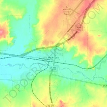
Nome: Mappa topografica Holbrook, altitudine, rilievo.
Luogo: Holbrook, Navajo County, Arizona, 86025, United States (34.86647 -110.21886 34.94682 -110.12761)
Altitudine media: 1’571 m
Altitudine minima: 1’538 m
Altitudine massima: 1’618 m
Fai una donazione
Equipaggiati per la tua prossima avventura:
In qualità di Affiliato Amazon, questo sito riceve una commissione sugli acquisti idonei, senza costi aggiuntivi per l’utente.
Altre mappe topografiche
Clicca su una mappa per visualizzarne la topografia, l'altitudine e il rilievo.
Monument Valley
United States > Arizona > Navajo County
The area is part of the Colorado Plateau. The elevation of the valley floor ranges from 5,000 to 6,000 feet (1,500 to 1,800 m) above sea level. The floor is largely siltstone of the Cutler Group, or sand derived from it, deposited by the meandering rivers that carved the valley. The valley's vivid red color…
Altitudine media: 1’675 m
Fai una donazione
Equipaggiati per la tua prossima avventura:
In qualità di Affiliato Amazon, questo sito riceve una commissione sugli acquisti idonei, senza costi aggiuntivi per l’utente.
Fai una donazione
Equipaggiati per la tua prossima avventura:
In qualità di Affiliato Amazon, questo sito riceve una commissione sugli acquisti idonei, senza costi aggiuntivi per l’utente.
Heber-Overgaard
United States > Arizona > Navajo County
Heber-Overgaard is a census-designated place (CDP) in Navajo County, Arizona, United States. Situated atop the Mogollon Rim, the community lies at an elevation of 6,627 feet (2,020 m). The population was 2,898 at the 2020 census. Heber and Overgaard are technically two unincorporated communities, but as of the…
Altitudine media: 2’015 m
Fai una donazione
Equipaggiati per la tua prossima avventura:
In qualità di Affiliato Amazon, questo sito riceve una commissione sugli acquisti idonei, senza costi aggiuntivi per l’utente.
Fai una donazione
Equipaggiati per la tua prossima avventura:
In qualità di Affiliato Amazon, questo sito riceve una commissione sugli acquisti idonei, senza costi aggiuntivi per l’utente.
West Mitten
United States > Arizona > Navajo County
The Mittens are about 0.6 mi (0.97 km) from the Arizona–Utah state line and West Mitten Butte is 1.1 mi (1.8 km) northeast of the park headquarters. The summit of West Mitten Butte is 6,176 ft (1,882 m) and East Mitten Butte is 6,226 ft (1,898 m) in elevation. The Mittens form a triangle with Merrick Butte…
Altitudine media: 1’616 m
Monument Valley
United States > Arizona > Navajo County
The area is part of the Colorado Plateau. The elevation of the valley floor ranges from 5,000 to 6,000 feet (1,500 to 1,800 m) above sea level. The floor is largely siltstone of the Cutler Group, or sand derived from it, deposited by the meandering rivers that carved the valley. The valley's vivid red color…
Altitudine media: 1’675 m
Kayenta
United States > Arizona > Navajo County
Kayenta is located at 36°42′43″N 110°15′00″W / 36.71194°N 110.25000°W / 36.71194; -110.25000 (36.7118, -110.2505), at an elevation of 5,700 feet, (1,738 m).
Altitudine media: 1’743 m
Fai una donazione
Equipaggiati per la tua prossima avventura:
In qualità di Affiliato Amazon, questo sito riceve una commissione sugli acquisti idonei, senza costi aggiuntivi per l’utente.
Heber-Overgaard
United States > Arizona > Navajo County
Heber-Overgaard is a census-designated place (CDP) in Navajo County, Arizona, United States. Situated atop the Mogollon Rim, the community lies at an elevation of 6,627 feet (2,020 m). The population was 2,898 at the 2020 census. Heber and Overgaard are technically two unincorporated communities, but as of the…
Altitudine media: 2’015 m
Monument Valley
United States > Arizona > Navajo County
The area is part of the Colorado Plateau. The elevation of the valley floor ranges from 5,000 to 6,000 feet (1,500 to 1,800 m) above sea level. The floor is largely siltstone of the Cutler Group, or sand derived from it, deposited by the meandering rivers that carved the valley. The valley's vivid red color…
Altitudine media: 1’675 m
Three Sisters
United States > Arizona > Navajo County
Monument Valley is part of the Colorado Plateau. The elevation of the valley floor ranges from 5,000 to 6,000 feet (1,500 to 1,800 m) above sea level. The floor is largely siltstone of the Cutler Group, or sand derived from it, deposited by the meandering rivers that carved the valley. The valley's vivid red…
Altitudine media: 1’664 m
Fai una donazione
Equipaggiati per la tua prossima avventura:
In qualità di Affiliato Amazon, questo sito riceve una commissione sugli acquisti idonei, senza costi aggiuntivi per l’utente.
Three Sisters
United States > Arizona > Navajo County
The area is part of the Colorado Plateau. The elevation of the valley floor ranges from 5,000 to 6,000 feet (1,500 to 1,800 m) above sea level. The floor is largely siltstone of the Cutler Group, or sand derived from it, deposited by the meandering rivers that carved the valley. The valley's vivid red color…
Altitudine media: 1’664 m
Fai una donazione
Equipaggiati per la tua prossima avventura:
In qualità di Affiliato Amazon, questo sito riceve una commissione sugli acquisti idonei, senza costi aggiuntivi per l’utente.
Marsh Pass
United States > Arizona > Navajo County > Tsegi
Marsh Pass, also known as La Puerta Limita, "The Border Gate", is a gap in Navajo County, Arizona. It lies at an elevation of 6,102 feet (1,860 meters) along Laguña Creek. The name of Marsh Pass is thought to come from its location along a chain of swamps and lakes in the pass, that have since been drained by…
Altitudine media: 1’961 m
Fai una donazione
Equipaggiati per la tua prossima avventura:
In qualità di Affiliato Amazon, questo sito riceve una commissione sugli acquisti idonei, senza costi aggiuntivi per l’utente.
Monument Valley
United States > Arizona > Navajo County
The area is part of the Colorado Plateau. The elevation of the valley floor ranges from 5,000 to 6,000 feet (1,500 to 1,800 m) above sea level. The floor is largely siltstone of the Cutler Group, or sand derived from it, deposited by the meandering rivers that carved the valley. The valley's vivid red color…
Altitudine media: 1’675 m