
Mappa topografica Mount Raleigh
Clicca sulla mappa per visualizzare l'altitudine.
Mount Raleigh
Mount Raleigh, elevation 3,132 m (10,276 ft), is one of the principal summits of the Pacific Ranges of the Coast Mountains of southern British Columbia in Canada. It is located just southeast of the confluence of the Southgate and Bishop Rivers, northeast of the head of Bute Inlet, and is the highest summit south of the Bishop River's divide with the Lillooet River at Ring Pass, which is at the southeastern edge of the Lillooet Icefield and just north of the Pemberton Icecap. It is also the highest peak south of the pass between the upper basins of Chilko Lake and the Taseko Lakes, just north of which is Monmouth Mountain at 3,182 m (10,440 ft) (see Tsʼilʔos Provincial Park).
A proposito di questa mappa
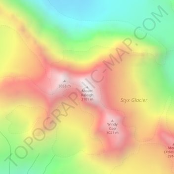
Nome: Mappa topografica Mount Raleigh, altitudine, rilievo.
Altitudine media: 2’414 m
Altitudine minima: 1’694 m
Altitudine massima: 3’110 m
Altre mappe topografiche
Clicca su una mappa per visualizzarne la topografia, l'altitudine e il rilievo.
Quadra Island
Canada > British Columbia > Strathcona Regional District > Area B (Discovery Islands/Mainland Inlets)
Altitudine media: 128 m
Bute Inlet
Canada > British Columbia > Strathcona Regional District > Area B (Discovery Islands/Mainland Inlets)
The Bute Inlet route was later considered for the mainline of the Canadian Pacific Railway (CPR), which would have seen extensive blasting down the west shore of the inlet and a series of bridges to reach Vancouver Island near Campbell River via Seymour Narrows. This route was passed over in favour of the…
Altitudine media: 921 m
Whiterock Passage
Canada > British Columbia > Strathcona Regional District > Area B (Discovery Islands/Mainland Inlets)
Altitudine media: 174 m
East Redonda Island
Canada > British Columbia > Strathcona Regional District > Area B (Discovery Islands/Mainland Inlets)
Altitudine media: 327 m
Yorke Island
Canada > British Columbia > Strathcona Regional District > Area B (Discovery Islands/Mainland Inlets)
Altitudine media: 9 m
Sonora Island
Canada > British Columbia > Strathcona Regional District > Area B (Discovery Islands/Mainland Inlets)
Altitudine media: 186 m
Broken Islands
Canada > British Columbia > Strathcona Regional District > Area B (Discovery Islands/Mainland Inlets)
Altitudine media: 10 m
Hardwicke Island
Canada > British Columbia > Strathcona Regional District > Area B (Discovery Islands/Mainland Inlets)
Altitudine media: 132 m
Heriot Bay
Canada > British Columbia > Strathcona Regional District > Area B (Discovery Islands/Mainland Inlets) > Heriot Bay
Altitudine media: 44 m
Jackson Bay
Canada > British Columbia > Strathcona Regional District > Area B (Discovery Islands/Mainland Inlets)
Altitudine media: 118 m
Quadra Island
Canada > British Columbia > Strathcona Regional District > Area B (Discovery Islands/Mainland Inlets)
Altitudine media: 128 m