
Fai una donazione
Equipaggiati per la tua prossima avventura:
In qualità di Affiliato Amazon, questo sito riceve una commissione sugli acquisti idonei, senza costi aggiuntivi per l’utente.
Mappa topografica Willow Street
Clicca sulla mappa per visualizzare l'altitudine.
Fai una donazione
Equipaggiati per la tua prossima avventura:
In qualità di Affiliato Amazon, questo sito riceve una commissione sugli acquisti idonei, senza costi aggiuntivi per l’utente.
Willow Street
Pennsylvania Route 272 (Willow Street Pike) is the main highway through the community. It is split into two one-way streets, with the northbound lanes following the original main street through the town, and the southbound lanes running four blocks to the west. PA 272 leads north 4 miles (6 km) to the center of Lancaster, the county seat, and south 15 miles (24 km) to Wakefield. U.S. Route 222 joins PA 272 in the north part of the CDP (shown as "Mylin Corners" on USGS topographic maps) and leads north into Lancaster but southeast 10 miles (16 km) to Quarryville.
Fai una donazione
Equipaggiati per la tua prossima avventura:
In qualità di Affiliato Amazon, questo sito riceve una commissione sugli acquisti idonei, senza costi aggiuntivi per l’utente.
A proposito di questa mappa
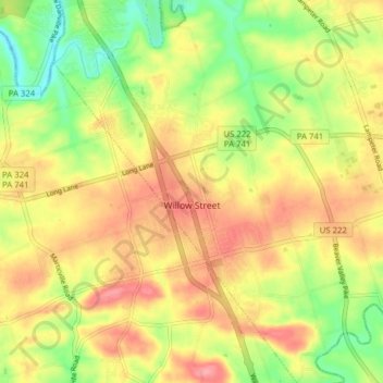
Nome: Mappa topografica Willow Street, altitudine, rilievo.
Luogo: Willow Street, Lancaster County, Pennsylvania, United States (39.95160 -76.29495 40.01138 -76.24527)
Altitudine media: 120 m
Altitudine minima: 68 m
Altitudine massima: 165 m
Fai una donazione
Equipaggiati per la tua prossima avventura:
In qualità di Affiliato Amazon, questo sito riceve una commissione sugli acquisti idonei, senza costi aggiuntivi per l’utente.