
Fai una donazione
Equipaggiati per la tua prossima avventura:
In qualità di Affiliato Amazon, questo sito riceve una commissione sugli acquisti idonei, senza costi aggiuntivi per l’utente.
Mappa topografica Israel
Clicca sulla mappa per visualizzare l'altitudine.
Fai una donazione
Equipaggiati per la tua prossima avventura:
In qualità di Affiliato Amazon, questo sito riceve una commissione sugli acquisti idonei, senza costi aggiuntivi per l’utente.
A proposito di questa mappa
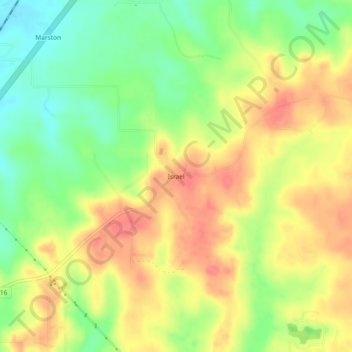
Nome: Mappa topografica Israel, altitudine, rilievo.
Luogo: Israel, Polk County, Texas, United States (30.72242 -94.91188 30.76242 -94.87188)
Altitudine media: 87 m
Altitudine minima: 53 m
Altitudine massima: 117 m
Fai una donazione
Equipaggiati per la tua prossima avventura:
In qualità di Affiliato Amazon, questo sito riceve una commissione sugli acquisti idonei, senza costi aggiuntivi per l’utente.
Altre mappe topografiche
Clicca su una mappa per visualizzarne la topografia, l'altitudine e il rilievo.
Lake Livingston
United States > Texas > Polk County
The earthfill dam has a concrete spillway and was designed by Brown and Root, Incorporated (now KBR, Inc). The dam has a spillway crest elevation of 99 feet (30 m) above mean sea level. The average base width of the dam's earthen embankment is 310 feet (94 m) wide. The spillway is designed and constructed to…
Altitudine media: 66 m
Onalaska
United States > Texas > Polk County
The city's terrain is characterized by gently rolling hills and piney woods typical of the East Texas Timberlands region. Elevations within Onalaska range from approximately 128 feet (39 m) to 253 feet (77 m) above sea level, with an average elevation around 161 feet (49 m).
Altitudine media: 49 m
Fai una donazione
Equipaggiati per la tua prossima avventura:
In qualità di Affiliato Amazon, questo sito riceve una commissione sugli acquisti idonei, senza costi aggiuntivi per l’utente.
Lake Livingston
United States > Texas > Polk County
The earthfill dam has a concrete spillway and was designed by Brown and Root, Incorporated (now KBR, Inc). The dam has a spillway crest elevation of 99 feet (30 m) above mean sea level. The average base width of the dam's earthen embankment is 310 feet (94 m) wide. The spillway is designed and constructed to…
Altitudine media: 66 m
Fai una donazione
Equipaggiati per la tua prossima avventura:
In qualità di Affiliato Amazon, questo sito riceve una commissione sugli acquisti idonei, senza costi aggiuntivi per l’utente.