
Mappa topografica Cobham
Mappa interattiva
Clicca sulla mappa per visualizzare l'altitudine.
Cobham
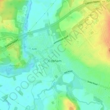
The River Mole runs through Cobham, with a visitor area and well-surfaced path by the mill in the High Street, dividing the low-rise urban village/town centre from the remaining agricultural parts of Cobham in the west and south. This can flood small, old parts of the village centre in extreme rainfall. Elevation reaches a minimum here of 20 metres (66 ft) above sea level.[16][17]
A proposito di questa mappa
Nome: Mappa topografica Cobham, altitudine, rilievo.
Luogo: Cobham, Elmbridge, Surrey, England, United Kingdom (51.32439 -0.42790 51.33843 -0.39933)
Altitudine media: 28 m
Altitudine minima: 14 m
Altitudine massima: 51 m
Altre mappe topografiche
Clicca su una mappa per visualizzarne la topografia, l'altitudine e il rilievo.
Esher
United Kingdom > England > Surrey > Elmbridge
Esher is an outlying suburb of London near the London-Surrey Border, and with Esher Commons at its southern end, the town marks one limit of the Greater London Built-Up Area. Esher has a linear commercial high street and is otherwise suburban in density, with varying elevations, few high rise buildings and…
Altitudine media: 27 m