
Mappa topografica Calvert
Clicca sulla mappa per visualizzare l'altitudine.
Calvert
The Main Line railway passes through Calvert as does Western Creek, a tributary of the Bremer River. A 2014 flood mapping study of the Western Creek catchment has provided more reliable flood information to residents and landowners. In the northern extents elevations rise to 340 metres above sea level around Mount Grandchester No. 2. which is part of the Little Liverpool Range. The landscape in the southern parts of Calvert is mostly used for agriculture.
A proposito di questa mappa
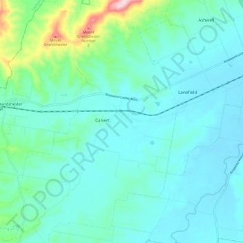
Nome: Mappa topografica Calvert, altitudine, rilievo.
Luogo: Calvert, Ipswich City, Queensland, 4340, Australia (-27.71852 152.46944 -27.61777 152.54780)
Altitudine media: 96 m
Altitudine minima: 41 m
Altitudine massima: 380 m
Altre mappe topografiche
Clicca su una mappa per visualizzarne la topografia, l'altitudine e il rilievo.