
Fai una donazione
Equipaggiati per la tua prossima avventura:
In qualità di Affiliato Amazon, questo sito riceve una commissione sugli acquisti idonei, senza costi aggiuntivi per l’utente.
Mappa topografica Kengle
Clicca sulla mappa per visualizzare l'altitudine.
Fai una donazione
Equipaggiati per la tua prossima avventura:
In qualità di Affiliato Amazon, questo sito riceve una commissione sugli acquisti idonei, senza costi aggiuntivi per l’utente.
A proposito di questa mappa
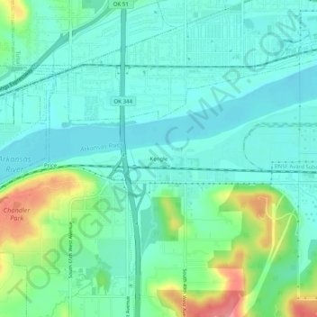
Nome: Mappa topografica Kengle, altitudine, rilievo.
Luogo: Kengle, Tulsa, Oklahoma, 74127, United States (36.11648 -96.07139 36.15648 -96.03139)
Altitudine media: 209 m
Altitudine minima: 184 m
Altitudine massima: 283 m
Fai una donazione
Equipaggiati per la tua prossima avventura:
In qualità di Affiliato Amazon, questo sito riceve una commissione sugli acquisti idonei, senza costi aggiuntivi per l’utente.
Altre mappe topografiche
Clicca su una mappa per visualizzarne la topografia, l'altitudine e il rilievo.
Tulsa
United States > Oklahoma > Tulsa
Tulsa, located in northeastern Oklahoma, is characterized by a diverse and rolling topography that marks its transition from the Great Plains to the Ozark foothills. The city's elevation averages around 700 feet (approximately 210 meters) above sea level, with some areas reaching heights of up to 1,050 feet…
Altitudine media: 221 m
Bixby
United States > Oklahoma > Tulsa
Bixby is located at 35°57′39″N 95°52′42″W / 35.96083°N 95.87833°W / 35.96083; -95.87833 (35.960898, −95.878258). According to the United States Census Bureau, the city has a total area of 25.1 square miles (65.0 km2), of which 24.0 square miles (62.3 km2) is land and 1.0 square mile (2.7…
Altitudine media: 204 m
Fai una donazione
Equipaggiati per la tua prossima avventura:
In qualità di Affiliato Amazon, questo sito riceve una commissione sugli acquisti idonei, senza costi aggiuntivi per l’utente.
Tulsa
United States > Oklahoma > Tulsa
Tulsa is located in the northeastern corner of Oklahoma between the edge of the Great Plains and the foot of the Ozarks in a generally forested region of rolling hills. The city touches the eastern extent of the Cross Timbers, an ecoregion of forest and prairie transitioning from the drier plains of the west…
Altitudine media: 221 m
Fai una donazione
Equipaggiati per la tua prossima avventura:
In qualità di Affiliato Amazon, questo sito riceve una commissione sugli acquisti idonei, senza costi aggiuntivi per l’utente.
Tulsa
United States > Oklahoma > Tulsa
Tulsa is located in the northeastern corner of Oklahoma between the edge of the Great Plains and the foot of the Ozarks in a generally forested region of rolling hills. The city touches the eastern extent of the Cross Timbers, an ecoregion of forest and prairie transitioning from the drier plains of the west…
Altitudine media: 221 m
Broken Arrow
United States > Oklahoma > Tulsa
Broken Arrow is located in the northeastern corner of Oklahoma. The city is part of the state's Green Country region known for its green vegetation, hills and lakes. Green Country is the most topographically diverse portion of the state with seven of Oklahoma's 11 eco-regions.
Altitudine media: 205 m