
Mappa topografica Bad Laasphe
Clicca sulla mappa per visualizzare l'altitudine.
Bad Laasphe
The highest elevation in the municipal area rises to 694 m. It lies southwest of the main town at the outlying centre of Heiligenborn.
A proposito di questa mappa
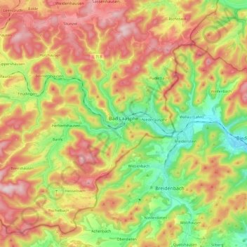
Nome: Mappa topografica Bad Laasphe, altitudine, rilievo.
Altitudine media: 464 m
Altitudine minima: 272 m
Altitudine massima: 672 m
Altre mappe topografiche
Clicca su una mappa per visualizzarne la topografia, l'altitudine e il rilievo.
Obernberg
Germany > North Rhine-Westphalia > Kreis Siegen-Wittgenstein > Bad Laasphe
Altitudine media: 488 m
Heisberg
Germany > North Rhine-Westphalia > Kreis Siegen-Wittgenstein > Freudenberg
Altitudine media: 338 m
Rüppershausen
Germany > North Rhine-Westphalia > Kreis Siegen-Wittgenstein > Bad Laasphe
Altitudine media: 497 m
NSG Erzebachtal
Germany > North Rhine-Westphalia > Kreis Siegen-Wittgenstein > Kreuztal > Fellinghausen
Altitudine media: 329 m