
Fai una donazione
Equipaggiati per la tua prossima avventura:
In qualità di Affiliato Amazon, questo sito riceve una commissione sugli acquisti idonei, senza costi aggiuntivi per l’utente.
Mappa topografica Eldersburg
Clicca sulla mappa per visualizzare l'altitudine.
Fai una donazione
Equipaggiati per la tua prossima avventura:
In qualità di Affiliato Amazon, questo sito riceve una commissione sugli acquisti idonei, senza costi aggiuntivi per l’utente.
A proposito di questa mappa
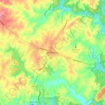
Nome: Mappa topografica Eldersburg, altitudine, rilievo.
Luogo: Eldersburg, Carroll County, Maryland, 21784, United States (39.36371 -76.99026 39.44371 -76.91026)
Altitudine media: 166 m
Altitudine minima: 114 m
Altitudine massima: 227 m
Fai una donazione
Equipaggiati per la tua prossima avventura:
In qualità di Affiliato Amazon, questo sito riceve una commissione sugli acquisti idonei, senza costi aggiuntivi per l’utente.
Altre mappe topografiche
Clicca su una mappa per visualizzarne la topografia, l'altitudine e il rilievo.
Westminster
United States > Maryland > Carroll County
Westminster lies in the humid subtropical climate zone, with hot and humid summers and cool winters with highly variable seasonal snowfall. Due to its elevation, distance from the Chesapeake Bay and urban heat island, temperatures in Westminster are often considerably lower than in Baltimore, especially at…
Altitudine media: 226 m
Mount Airy
United States > Maryland > Carroll County
The town was originally settled in the early 1830s by a core group of six families. Dorsey, Davis and Bussard were the most prominent names in that first settlement, which was followed closely by the construction of the B & O railroad line in 1831. Because Mount Airy sits at an elevation of 830 feet (250 m), a…
Altitudine media: 221 m
Fai una donazione
Equipaggiati per la tua prossima avventura:
In qualità di Affiliato Amazon, questo sito riceve una commissione sugli acquisti idonei, senza costi aggiuntivi per l’utente.
Fai una donazione
Equipaggiati per la tua prossima avventura:
In qualità di Affiliato Amazon, questo sito riceve una commissione sugli acquisti idonei, senza costi aggiuntivi per l’utente.
Mount Airy
United States > Maryland > Carroll County
The town was originally settled in the early 1830s by a core group of six families. Dorsey, Davis and Bussard were the most prominent names in that first settlement, which was followed closely by the construction of the B & O railroad line in 1831. Because Mount Airy sits at an elevation of 830 feet (250 m), a…
Altitudine media: 221 m
Fai una donazione
Equipaggiati per la tua prossima avventura:
In qualità di Affiliato Amazon, questo sito riceve una commissione sugli acquisti idonei, senza costi aggiuntivi per l’utente.
Westminster
United States > Maryland > Carroll County
Westminster lies in the humid subtropical climate zone bordering on a humid continental climate, with hot and humid summers and cool winters with highly variable seasonal snowfall. Due to its elevation, distance from the Chesapeake Bay and urban heat island, temperatures in Westminster are often considerably…
Altitudine media: 228 m