
Fai una donazione
Equipaggiati per la tua prossima avventura:
In qualità di Affiliato Amazon, questo sito riceve una commissione sugli acquisti idonei, senza costi aggiuntivi per l’utente.
Mappa topografica North Las Vegas
Clicca sulla mappa per visualizzare l'altitudine.
Fai una donazione
Equipaggiati per la tua prossima avventura:
In qualità di Affiliato Amazon, questo sito riceve una commissione sugli acquisti idonei, senza costi aggiuntivi per l’utente.
North Las Vegas
On May 13, 1964, First Lieutenant Raynor Lee Hebert, a student pilot from Port Arthur, Texas, took off from Nellis Air Force Base at approximately 2:00 PM on an F-105 fighter jet. He radioed his flight leader saying that he could not retract his nose gear, and thus could not gain altitude. He was at a height high enough to bail out, but too low that if he did, he would've hit Lincoln Elementary School, which was in session with 800 students. He kept the plane nose up long enough to pass the school, and eventually hit nine residential houses on Lenwood Avenue. The crash killed Hebert and four civilians. Hebert Memorial Park was created by the City of North Las Vegas with a plaque at the crash site to commemorate Hebert.
Fai una donazione
Equipaggiati per la tua prossima avventura:
In qualità di Affiliato Amazon, questo sito riceve una commissione sugli acquisti idonei, senza costi aggiuntivi per l’utente.
A proposito di questa mappa
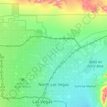
Nome: Mappa topografica North Las Vegas, altitudine, rilievo.
Luogo: North Las Vegas, Clark County, Nevada, United States (36.18483 -115.21202 36.33589 -114.95455)
Altitudine media: 684 m
Altitudine minima: 527 m
Altitudine massima: 1’307 m
Fai una donazione
Equipaggiati per la tua prossima avventura:
In qualità di Affiliato Amazon, questo sito riceve una commissione sugli acquisti idonei, senza costi aggiuntivi per l’utente.
Altre mappe topografiche
Clicca su una mappa per visualizzarne la topografia, l'altitudine e il rilievo.
Highland Range Crucial Bighorn Habitat Area
United States > Nevada > Clark County
Altitudine media: 917 m
Fai una donazione
Equipaggiati per la tua prossima avventura:
In qualità di Affiliato Amazon, questo sito riceve una commissione sugli acquisti idonei, senza costi aggiuntivi per l’utente.
Fai una donazione
Equipaggiati per la tua prossima avventura:
In qualità di Affiliato Amazon, questo sito riceve una commissione sugli acquisti idonei, senza costi aggiuntivi per l’utente.
Craig Ranch Regional Park
United States > Nevada > Clark County > North Las Vegas
Altitudine media: 626 m
Fai una donazione
Equipaggiati per la tua prossima avventura:
In qualità di Affiliato Amazon, questo sito riceve una commissione sugli acquisti idonei, senza costi aggiuntivi per l’utente.
Mount Charleston
United States > Nevada > Clark County
The town of Mount Charleston is named for nearby Mount Charleston whose Charleston Peak at 11,916 feet (3,632 m) is the highest point in Clark County. The town of Mount Charleston is in a valley of the Spring Mountains to the northwest of Las Vegas, noted for its hiking trails. It is also known for its Retreat…
Altitudine media: 2’594 m
Spring Mountain Ranch State Park
United States > Nevada > Clark County
"Because of the higher elevation, the ranch offers a diverse opportunity for plant study. Four plant communities are represented: Desert Scrub, Black brush, Pinon-Juniper, and Riparian. Plants typical of the desert as well as woodland can be seen, and with adequate rainfall the spring brings a burst of…
Altitudine media: 1’188 m
Fai una donazione
Equipaggiati per la tua prossima avventura:
In qualità di Affiliato Amazon, questo sito riceve una commissione sugli acquisti idonei, senza costi aggiuntivi per l’utente.
Fai una donazione
Equipaggiati per la tua prossima avventura:
In qualità di Affiliato Amazon, questo sito riceve una commissione sugli acquisti idonei, senza costi aggiuntivi per l’utente.
Blue Diamond
United States > Nevada > Clark County
Blue Diamond is the site of Cottonwood Spring (formerly known as Ojo de Cayetana, or Pearl Spring), a watering place and campsite on the Old Spanish Trail and the later Mormon Road between Mountain Springs and Las Vegas Springs. The springs are located on a mountainside south of the town at 36°02′44″N…
Altitudine media: 1’106 m
Fai una donazione
Equipaggiati per la tua prossima avventura:
In qualità di Affiliato Amazon, questo sito riceve una commissione sugli acquisti idonei, senza costi aggiuntivi per l’utente.
Mount Charleston
United States > Nevada > Clark County
The town of Mount Charleston is named for nearby Mount Charleston whose Charleston Peak at 11,916 feet (3,632 m) is the highest point in Clark County. The town of Mount Charleston is in a valley of the Spring Mountains to the northwest of Las Vegas, noted for its hiking trails. It is also known for its Retreat…
Altitudine media: 2’594 m
Fai una donazione
Equipaggiati per la tua prossima avventura:
In qualità di Affiliato Amazon, questo sito riceve una commissione sugli acquisti idonei, senza costi aggiuntivi per l’utente.