
Fai una donazione
Equipaggiati per la tua prossima avventura:
In qualità di Affiliato Amazon, questo sito riceve una commissione sugli acquisti idonei, senza costi aggiuntivi per l’utente.
Mappa topografica Surajkund
Clicca sulla mappa per visualizzare l'altitudine.
Fai una donazione
Equipaggiati per la tua prossima avventura:
In qualità di Affiliato Amazon, questo sito riceve una commissione sugli acquisti idonei, senza costi aggiuntivi per l’utente.
Surajkund
In the Aravalli hill ranges, which spreads over Delhi and Haryana, where the Surajkund and the Anagpur Dam are located, ancient Stone Age relics have been revealed. The Aravallis, which strike out in two directions from Delhi exhibits a topography of low and rugged hills. The stratigraphy in the area is considered to consist of reddish rocks and scrub and has the luxuriance of the Stone Age progression. Stone Age material have been unearthed in the region at 43 sites on the road from Delhi to Surajkund and south of the Suraj Kund-Faridabad road, Anangpur hills and Ankhir pahari on the road on the low ridge from Faridabad to Surajkund. The Stone Age relics comprise Microliths and lower Paleolithics.
Fai una donazione
Equipaggiati per la tua prossima avventura:
In qualità di Affiliato Amazon, questo sito riceve una commissione sugli acquisti idonei, senza costi aggiuntivi per l’utente.
A proposito di questa mappa
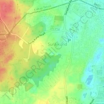
Nome: Mappa topografica Surajkund, altitudine, rilievo.
Luogo: Surajkund, Suraj Kund Road, Faridabad, Haryana, 121001, India (28.48303 77.28233 28.48448 77.28367)
Altitudine media: 230 m
Altitudine minima: 203 m
Altitudine massima: 264 m
Fai una donazione
Equipaggiati per la tua prossima avventura:
In qualità di Affiliato Amazon, questo sito riceve una commissione sugli acquisti idonei, senza costi aggiuntivi per l’utente.