
Fai una donazione
Equipaggiati per la tua prossima avventura:
In qualità di Affiliato Amazon, questo sito riceve una commissione sugli acquisti idonei, senza costi aggiuntivi per l’utente.
Mappa topografica Quimiac
Clicca sulla mappa per visualizzare l'altitudine.
Fai una donazione
Equipaggiati per la tua prossima avventura:
In qualità di Affiliato Amazon, questo sito riceve una commissione sugli acquisti idonei, senza costi aggiuntivi per l’utente.
A proposito di questa mappa
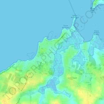
Nome: Mappa topografica Quimiac, altitudine, rilievo.
Altitudine media: 6 m
Altitudine minima: -4 m
Altitudine massima: 25 m
Fai una donazione
Equipaggiati per la tua prossima avventura:
In qualità di Affiliato Amazon, questo sito riceve una commissione sugli acquisti idonei, senza costi aggiuntivi per l’utente.
Altre mappe topografiche
Clicca su una mappa per visualizzarne la topografia, l'altitudine e il rilievo.
Nantes
France > Pays de la Loire > Loire-Atlantique
Nantes is built on the Armorican Massif, a range of weathered mountains which may be considered the backbone of Brittany. The mountains, stretching from the end of the Breton peninsula to the outskirts of the sedimentary Paris Basin, are composed of several parallel ridges of Ordovician and Cadomian rocks.…
Altitudine media: 26 m
Fai una donazione
Equipaggiati per la tua prossima avventura:
In qualità di Affiliato Amazon, questo sito riceve una commissione sugli acquisti idonei, senza costi aggiuntivi per l’utente.
Nantes
France > Pays de la Loire > Loire-Atlantique
Nantes is built on the Armorican Massif, a range of weathered mountains which may be considered the backbone of Brittany. The mountains, stretching from the end of the Breton peninsula to the outskirts of the sedimentary Paris Basin, are composed of several parallel ridges of Ordovician and Cadomian rocks.…
Altitudine media: 26 m
Fai una donazione
Equipaggiati per la tua prossima avventura:
In qualità di Affiliato Amazon, questo sito riceve una commissione sugli acquisti idonei, senza costi aggiuntivi per l’utente.
Fai una donazione
Equipaggiati per la tua prossima avventura:
In qualità di Affiliato Amazon, questo sito riceve una commissione sugli acquisti idonei, senza costi aggiuntivi per l’utente.
Nantes
France > Pays de la Loire > Loire-Atlantique
Nantes is built on the Armorican Massif, a range of weathered mountains which may be considered the backbone of Brittany. The mountains, stretching from the end of the Breton peninsula to the outskirts of the sedimentary Paris Basin, are composed of several parallel ridges of Ordovician and Cadomian rocks.…
Altitudine media: 26 m
Fai una donazione
Equipaggiati per la tua prossima avventura:
In qualità di Affiliato Amazon, questo sito riceve una commissione sugli acquisti idonei, senza costi aggiuntivi per l’utente.
Saint-Nazaire
France > Pays de la Loire > Loire-Atlantique
According to INSEE, Saint-Nazaire is the commune-center of an urban unit (commonly: agglomeration) which counted 186,760 inhabitants in 2018, gathering 17 communes of the Loire estuary. This unit is the urban center of the urban area of Saint-Nazaire (24 communes), which had 213,675 inhabitants in 2018 and…
Altitudine media: 6 m
Fai una donazione
Equipaggiati per la tua prossima avventura:
In qualità di Affiliato Amazon, questo sito riceve una commissione sugli acquisti idonei, senza costi aggiuntivi per l’utente.
Nantes
France > Pays de la Loire > Loire-Atlantique
Nantes is built on the Armorican Massif, a range of weathered mountains which may be considered the backbone of Brittany. The mountains, stretching from the end of the Breton peninsula to the outskirts of the sedimentary Paris Basin, are composed of several parallel ridges of Ordovician and Cadomian rocks.…
Altitudine media: 26 m
Fai una donazione
Equipaggiati per la tua prossima avventura:
In qualità di Affiliato Amazon, questo sito riceve una commissione sugli acquisti idonei, senza costi aggiuntivi per l’utente.
Fai una donazione
Equipaggiati per la tua prossima avventura:
In qualità di Affiliato Amazon, questo sito riceve una commissione sugli acquisti idonei, senza costi aggiuntivi per l’utente.
Fai una donazione
Equipaggiati per la tua prossima avventura:
In qualità di Affiliato Amazon, questo sito riceve una commissione sugli acquisti idonei, senza costi aggiuntivi per l’utente.
44115
France > Pays de la Loire > Loire-Atlantique > Haute-Goulaine > La Bellaudière
Altitudine media: 16 m
Fai una donazione
Equipaggiati per la tua prossima avventura:
In qualità di Affiliato Amazon, questo sito riceve una commissione sugli acquisti idonei, senza costi aggiuntivi per l’utente.
Nantes
France > Pays de la Loire > Loire-Atlantique
Nantes is built on the Armorican Massif, a range of weathered mountains which may be considered the backbone of Brittany. The mountains, stretching from the end of the Breton peninsula to the outskirts of the sedimentary Paris Basin, are composed of several parallel ridges of Ordovician and Cadomian rocks.…
Altitudine media: 26 m
Fai una donazione
Equipaggiati per la tua prossima avventura:
In qualità di Affiliato Amazon, questo sito riceve una commissione sugli acquisti idonei, senza costi aggiuntivi per l’utente.
Fai una donazione
Equipaggiati per la tua prossima avventura:
In qualità di Affiliato Amazon, questo sito riceve una commissione sugli acquisti idonei, senza costi aggiuntivi per l’utente.
Fai una donazione
Equipaggiati per la tua prossima avventura:
In qualità di Affiliato Amazon, questo sito riceve una commissione sugli acquisti idonei, senza costi aggiuntivi per l’utente.
Fai una donazione
Equipaggiati per la tua prossima avventura:
In qualità di Affiliato Amazon, questo sito riceve una commissione sugli acquisti idonei, senza costi aggiuntivi per l’utente.
Fresnay-en-Retz
France > Pays de la Loire > Loire-Atlantique > Villeneuve-en-Retz
Altitudine media: 18 m
Fai una donazione
Equipaggiati per la tua prossima avventura:
In qualità di Affiliato Amazon, questo sito riceve una commissione sugli acquisti idonei, senza costi aggiuntivi per l’utente.