
Fai una donazione
Equipaggiati per la tua prossima avventura:
In qualità di Affiliato Amazon, questo sito riceve una commissione sugli acquisti idonei, senza costi aggiuntivi per l’utente.
Mappa topografica Sheep Mountain Table
Clicca sulla mappa per visualizzare l'altitudine.
Fai una donazione
Equipaggiati per la tua prossima avventura:
In qualità di Affiliato Amazon, questo sito riceve una commissione sugli acquisti idonei, senza costi aggiuntivi per l’utente.
A proposito di questa mappa
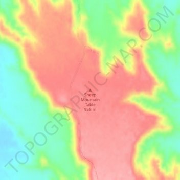
Nome: Mappa topografica Sheep Mountain Table, altitudine, rilievo.
Altitudine media: 922 m
Altitudine minima: 857 m
Altitudine massima: 975 m
Fai una donazione
Equipaggiati per la tua prossima avventura:
In qualità di Affiliato Amazon, questo sito riceve una commissione sugli acquisti idonei, senza costi aggiuntivi per l’utente.
Altre mappe topografiche
Clicca su una mappa per visualizzarne la topografia, l'altitudine e il rilievo.
Rapid City
United States > South Dakota > Pennington County
Rapid City is located at 44°04′34″N 103°13′42″W / 44.076188°N 103.228299°W / 44.076188; -103.228299. The downtown elevation of Rapid City is 3,202 feet (976 m). Rapid City is located in the shadow of Black Elk Peak, which at 7,242 feet (2,207 m), is the highest point east of the Rocky Mountains.
Altitudine media: 1’067 m
Rapid City
United States > South Dakota > Pennington County
Rapid City is located at 44°04′34″N 103°13′42″W / 44.076188°N 103.228299°W / 44.076188; -103.228299. The downtown elevation of Rapid City is 3,202 feet (976 m). Rapid City is located in the shadow of Black Elk Peak, which at 7,242 feet (2,207 m), is the highest point east of the Rocky Mountains.
Altitudine media: 1’068 m
Mount Rushmore National Memorial
United States > South Dakota > Pennington County
The Mount Rushmore National Memorial is a national memorial centered on a colossal sculpture carved into the granite face of Mount Rushmore (Lakota: Tȟuŋkášila Šákpe, or Six Grandfathers) in the Black Hills near Keystone, South Dakota, United States. Sculptor Gutzon Borglum designed the sculpture, called…
Altitudine media: 1’528 m
Fai una donazione
Equipaggiati per la tua prossima avventura:
In qualità di Affiliato Amazon, questo sito riceve una commissione sugli acquisti idonei, senza costi aggiuntivi per l’utente.
Fai una donazione
Equipaggiati per la tua prossima avventura:
In qualità di Affiliato Amazon, questo sito riceve una commissione sugli acquisti idonei, senza costi aggiuntivi per l’utente.
Rapid City
United States > South Dakota > Pennington County
Rapid City is located at 44°04′34″N 103°13′42″W / 44.076188°N 103.228299°W / 44.076188; -103.228299. The downtown elevation of Rapid City is 3,202 feet (976 m). Rapid City is located in the shadow of Black Elk Peak, which at 7,242 feet (2,207 m), is the highest point east of the Rocky Mountains.
Altitudine media: 1’068 m
Fai una donazione
Equipaggiati per la tua prossima avventura:
In qualità di Affiliato Amazon, questo sito riceve una commissione sugli acquisti idonei, senza costi aggiuntivi per l’utente.
Mount Rushmore National Memorial
United States > South Dakota > Pennington County
Mount Rushmore National Memorial is a national memorial centered on a colossal sculpture carved into the granite face of Mount Rushmore (Lakota: Tȟuŋkášila Šákpe, or Six Grandfathers) in the Black Hills near Keystone, South Dakota, United States. Sculptor Gutzon Borglum created the sculpture's design and…
Altitudine media: 1’528 m