
Fai una donazione
Equipaggiati per la tua prossima avventura:
In qualità di Affiliato Amazon, questo sito riceve una commissione sugli acquisti idonei, senza costi aggiuntivi per l’utente.
Mappa topografica Araucania Region
Clicca sulla mappa per visualizzare l'altitudine.
Fai una donazione
Equipaggiati per la tua prossima avventura:
In qualità di Affiliato Amazon, questo sito riceve una commissione sugli acquisti idonei, senza costi aggiuntivi per l’utente.
A proposito di questa mappa
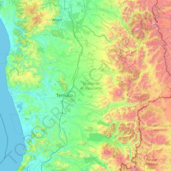
Nome: Mappa topografica Araucania Region, altitudine, rilievo.
Luogo: Araucania Region, Chile (-39.63722 -73.51907 -37.58180 -70.82646)
Altitudine media: 654 m
Altitudine minima: -2 m
Altitudine massima: 3’435 m
Fai una donazione
Equipaggiati per la tua prossima avventura:
In qualità di Affiliato Amazon, questo sito riceve una commissione sugli acquisti idonei, senza costi aggiuntivi per l’utente.
Altre mappe topografiche
Clicca su una mappa per visualizzarne la topografia, l'altitudine e il rilievo.
Santiago
Chile > Santiago Metropolitan Region > Provincia de Santiago
The city lies in the center of the Santiago Basin, a large bowl-shaped valley consisting of broad and fertile lands surrounded by mountains. The city has a varying elevation, gradually increasing from 400 m (1,312 ft) in the western areas to more than 700 m (2,297 ft) in the eastern areas. Santiago's…
Altitudine media: 722 m
Atacama Desert
Chile > Antofagasta Region > Provincia de Antofagasta > Antofagasta
The Coastal Cliff of northern Chile west of the Chilean Coast Range is the main topographical feature of the coast. The geomorphology of the Atacama Desert has been characterized as a low-relief bench "similar to a giant uplifted terrace" by Armijo and co-workers. The intermediate depression (or Central…
Altitudine media: 1’961 m
Santiago
Chile > Santiago Metropolitan Region > Provincia de Santiago
The city lies in the center of the Santiago Basin, a large bowl-shaped valley consisting of broad and fertile lands surrounded by mountains. The city has a varying elevation, gradually increasing from 400 m (1,312 ft) in the western areas to more than 700 m (2,297 ft) in the eastern areas. Santiago's…
Altitudine media: 724 m
Fai una donazione
Equipaggiati per la tua prossima avventura:
In qualità di Affiliato Amazon, questo sito riceve una commissione sugli acquisti idonei, senza costi aggiuntivi per l’utente.
Cerro Torre
Chile > Magallanes and Chilean Antarctica Region > Provincia de Última Esperanza > Puerto Natales
Altitudine media: 1’916 m
Fai una donazione
Equipaggiati per la tua prossima avventura:
In qualità di Affiliato Amazon, questo sito riceve una commissione sugli acquisti idonei, senza costi aggiuntivi per l’utente.
Zona Austral
Chile > Region of Magallanes and Chilean Antarctica > Provincia de Última Esperanza > Puerto Natales
In the far south (Chile Austral), which extends from Valdivia through the Chacao Channel to Cape Horn, the Andes and the South Pacific meet. This district of the country is mountainous, heavily forested and inhospitable. The deeply indented coastline is filled with islands which preserve the general outline of…
Altitudine media: 768 m
Canal de Relave Codelco División El Teniente
Chile > Provincia de Cachapoal > Requínoa
Altitudine media: 629 m
Carretera Austral
Chile > Aysen del General Carlos Ibanez del Campo Region > Provincia de General Carrera > Río Ibáñez
Altitudine media: 414 m
Ojos del Salado
Chile > Atacama Region > Provincia de Copiapó > Copiapó
Nevado Ojos del Salado is a dormant complex volcano in the Andes on the Argentina–Chile border. It is the highest volcano on Earth and the highest peak in Chile. The upper reaches of Ojos del Salado consist of several overlapping lava domes, lava flows and volcanic craters, with sparse ice cover. The complex…
Altitudine media: 6’446 m
Fai una donazione
Equipaggiati per la tua prossima avventura:
In qualità di Affiliato Amazon, questo sito riceve una commissione sugli acquisti idonei, senza costi aggiuntivi per l’utente.
Isla Carmen
Chile > Aysen del General Carlos Ibanez del Campo Region > Provincia de Aysén > Puerto Aysén
Altitudine media: 22 m
Humedal Desembocadura del Río Copiapó
Chile > Atacama Region > Provincia de Copiapó > Caldera
Altitudine media: 31 m
Fai una donazione
Equipaggiati per la tua prossima avventura:
In qualità di Affiliato Amazon, questo sito riceve una commissione sugli acquisti idonei, senza costi aggiuntivi per l’utente.
Yendegaia
Chile > Magallanes and Chilean Antarctica Region > Provincia de la Antártica Chilena > Cape Horn
Altitudine media: 91 m
Santiago
Chile > Santiago Metropolitan Region > Provincia de Santiago
The city lies in the center of the Santiago Basin, a large bowl-shaped valley consisting of broad and fertile lands surrounded by mountains. The city has a varying elevation, gradually increasing from 400 meters (1,300 feet) in the western areas to more than 700 m (2,297 ft) in the eastern areas. Santiago's…
Altitudine media: 722 m
Ma'uŋa Te Hoŋa (O Koro)
Chile > Valparaiso Region > Easter Island Province > Easter Island
Altitudine media: 255 m
Fai una donazione
Equipaggiati per la tua prossima avventura:
In qualità di Affiliato Amazon, questo sito riceve una commissione sugli acquisti idonei, senza costi aggiuntivi per l’utente.
Santiago
Chile > Santiago Metropolitan Region > Provincia de Santiago
The city lies in the center of the Santiago Basin, a large bowl-shaped valley consisting of broad and fertile lands surrounded by mountains. The city has a varying elevation, gradually increasing from 400 m (1,312 ft) in the western areas to more than 700 m (2,297 ft) in the eastern areas. Santiago's…
Altitudine media: 724 m
Fai una donazione
Equipaggiati per la tua prossima avventura:
In qualità di Affiliato Amazon, questo sito riceve una commissione sugli acquisti idonei, senza costi aggiuntivi per l’utente.
Puerto Natales
Chile > Magallanes and Chilean Antarctica Region > Provincia de Última Esperanza
Altitudine media: 141 m
Puerto Guadal
Chile > Aysen del General Carlos Ibanez del Campo Region > Provincia de General Carrera > Chile Chico
Altitudine media: 347 m
Camar
Chile > Antofagasta Region > Provincia de El Loa > San Pedro de Atacama
Altitudine media: 2’722 m
Fai una donazione
Equipaggiati per la tua prossima avventura:
In qualità di Affiliato Amazon, questo sito riceve una commissione sugli acquisti idonei, senza costi aggiuntivi per l’utente.
Mirador Cóndor
Chile > Magallanes and Chilean Antarctica Region > Provincia de Última Esperanza > Torres del Paine
Altitudine media: 140 m
Cerro Torre
Chile > Magallanes and Chilean Antarctica Region > Provincia de Última Esperanza
Altitudine media: 1’916 m
Fai una donazione
Equipaggiati per la tua prossima avventura:
In qualità di Affiliato Amazon, questo sito riceve una commissione sugli acquisti idonei, senza costi aggiuntivi per l’utente.
El Peumo
Chile > Santiago Metropolitan Region > Provincia de Talagante > Talagante
Altitudine media: 324 m
Santiago
Chile > Santiago Metropolitan Region > Provincia de Santiago
The city lies in the center of the Santiago Basin, a large bowl-shaped valley consisting of broad and fertile lands surrounded by mountains. The city has a varying elevation, gradually increasing from 400 m (1,312 ft) in the western areas to more than 700 m (2,297 ft) in the eastern areas. Santiago's…
Altitudine media: 724 m
Fai una donazione
Equipaggiati per la tua prossima avventura:
In qualità di Affiliato Amazon, questo sito riceve una commissione sugli acquisti idonei, senza costi aggiuntivi per l’utente.
Cerro El Monstruo
Chile > Los Lagos Region > Provincia de Llanquihue > Cochamó
Altitudine media: 1’296 m
Socaire
Chile > Antofagasta Region > Provincia de El Loa > San Pedro de Atacama
Altitudine media: 3’291 m
Fai una donazione
Equipaggiati per la tua prossima avventura:
In qualità di Affiliato Amazon, questo sito riceve una commissione sugli acquisti idonei, senza costi aggiuntivi per l’utente.
Fai una donazione
Equipaggiati per la tua prossima avventura:
In qualità di Affiliato Amazon, questo sito riceve una commissione sugli acquisti idonei, senza costi aggiuntivi per l’utente.
Valle del Aconcagua
Chile > Valparaiso Region > Provincia de Quillota > Hijuelas > La Sombra
Altitudine media: 349 m
Atacama Desert
Chile > Antofagasta Region > Provincia de Antofagasta > Antofagasta
The Coastal Cliff of northern Chile west of the Chilean Coast Range is the main topographical feature of the coast. The geomorphology of the Atacama Desert has been characterized as a low-relief bench "similar to a giant uplifted terrace" by Armijo and co-workers. The intermediate depression (or Central…
Altitudine media: 1’961 m
El Cobre
Chile > Valparaiso Region > Provincia de San Felipe de Aconcagua > Catemu
Altitudine media: 547 m
Fai una donazione
Equipaggiati per la tua prossima avventura:
In qualità di Affiliato Amazon, questo sito riceve una commissione sugli acquisti idonei, senza costi aggiuntivi per l’utente.
Laguna Lejía
Chile > Antofagasta Region > Provincia de El Loa > San Pedro de Atacama
Lejía Lake is a circular, shallow lake at an elevation of 4,325 metres (14,190 ft) with a surface area of 1.9 square kilometres (0.73 sq mi) or 2 square kilometres (0.77 sq mi). It is a polymictic lake which freezes over occasionally and whose waters are turned over quickly, mainly through evaporation. Winds…
Altitudine media: 4’341 m
Clear water
Chile > Aysen del General Carlos Ibanez del Campo Region > Provincia de Capitán Prat > O’Higgins
Altitudine media: 399 m
A018
Chile > Antofagasta Region > Provincia de El Loa > San Pedro de Atacama > Atacama Large Millimeter/submillimeter Array
Altitudine media: 5’021 m
Fai una donazione
Equipaggiati per la tua prossima avventura:
In qualità di Affiliato Amazon, questo sito riceve una commissione sugli acquisti idonei, senza costi aggiuntivi per l’utente.
Volcán Ojos del Toro
Chile > Antofagasta Region > Provincia de El Loa > San Pedro de Atacama
Altitudine media: 5’503 m
Fai una donazione
Equipaggiati per la tua prossima avventura:
In qualità di Affiliato Amazon, questo sito riceve una commissione sugli acquisti idonei, senza costi aggiuntivi per l’utente.
Isla Florencia
Chile > Aysen del General Carlos Ibanez del Campo Region > Provincia de Aysén > Cisnes
Altitudine media: 13 m
Tupungato
Chile > Santiago Metropolitan Region > Provincia de Cordillera > San José de Maipo
Altitudine media: 6’002 m
Placilla de Peñuelas
Chile > Valparaiso Region > Provincia de Valparaíso > Valparaíso
Altitudine media: 354 m
Fai una donazione
Equipaggiati per la tua prossima avventura:
In qualità di Affiliato Amazon, questo sito riceve una commissione sugli acquisti idonei, senza costi aggiuntivi per l’utente.
Tupungato
Chile > Santiago Metropolitan Region > Provincia de Cordillera > San José de Maipo
Altitudine media: 6’002 m
Fai una donazione
Equipaggiati per la tua prossima avventura:
In qualità di Affiliato Amazon, questo sito riceve una commissione sugli acquisti idonei, senza costi aggiuntivi per l’utente.
Parque Industrial Los Libertadores
Chile > Santiago Metropolitan Region > Provincia de Chacabuco > Colina
Altitudine media: 520 m
Fai una donazione
Equipaggiati per la tua prossima avventura:
In qualità di Affiliato Amazon, questo sito riceve una commissione sugli acquisti idonei, senza costi aggiuntivi per l’utente.
Puyuhuapi
Chile > Aysen del General Carlos Ibanez del Campo Region > Provincia de Aysén > Cisnes
Altitudine media: 229 m
San Alfonso
Chile > Santiago Metropolitan Region > Provincia de Cordillera > San José de Maipo
Altitudine media: 1’372 m
Fai una donazione
Equipaggiati per la tua prossima avventura:
In qualità di Affiliato Amazon, questo sito riceve una commissione sugli acquisti idonei, senza costi aggiuntivi per l’utente.
Punta Pite
Chile > Valparaiso Region > Provincia de Petorca > Zapallar > Punta Pite Norte
Altitudine media: 35 m
El Molino Viejo
Chile > O'Higgins Region > Provincia de Cachapoal > Requínoa > Pichiguao
Altitudine media: 373 m
Volcán Llullaillaco
Chile > Antofagasta Region > Provincia de Antofagasta > Antofagasta
Llullaillaco (Spanish: [ʎuʎajˈʎako], Latin American Spanish: [ɟʝuʝajˈʝako]) is a dormant stratovolcano on the border between Argentina (Salta Province) and Chile (Antofagasta Region). It is part of the Llullaillaco National Park and lies in the Puna de Atacama, a region of tall volcanic peaks on a…
Altitudine media: 6’187 m
Fai una donazione
Equipaggiati per la tua prossima avventura:
In qualità di Affiliato Amazon, questo sito riceve una commissione sugli acquisti idonei, senza costi aggiuntivi per l’utente.
Isla Florencia
Chile > Aysen del General Carlos Ibanez del Campo Region > Provincia de Aysén > Cisnes
Altitudine media: 13 m
Tronador
Chile > Los Lagos Region > Provincia de Llanquihue > Puerto Varas
Tronador (Spanish: Cerro Tronador) is an extinct stratovolcano in the southern Andes, located along the border between Argentina and Chile, near the Argentine city of Bariloche. The mountain was named Tronador (Spanish for "Thunderer") by locals in reference to the sound of falling seracs. With an altitude of…
Altitudine media: 2’836 m
Fai una donazione
Equipaggiati per la tua prossima avventura:
In qualità di Affiliato Amazon, questo sito riceve una commissione sugli acquisti idonei, senza costi aggiuntivi per l’utente.
Norte Grande
Chile > Antofagasta Region > Provincia de Antofagasta > Sierra Gorda
The desert region is an elevated arid plateau descending gradually from the Andes towards the coast, where it breaks down abruptly from elevations of 800 to 1500 ft. From the sea this plateau escarpment has the appearance of a range of flat topped hills closely following the coast line. This topography…
Altitudine media: 2’112 m
La Chupalla
Chile > Valparaiso Region > Provincia de San Felipe de Aconcagua > Llay-Llay
Altitudine media: 850 m
Fai una donazione
Equipaggiati per la tua prossima avventura:
In qualità di Affiliato Amazon, questo sito riceve una commissione sugli acquisti idonei, senza costi aggiuntivi per l’utente.
Caleta Camarones
Chile > Arica y Parinacota Region > Provincia de Arica > Camarones
Altitudine media: 188 m
Cerro Penitentes
Chile > Santiago Metropolitan Region > Provincia de Cordillera > San José de Maipo
Altitudine media: 3’717 m
Peteroa
Chile > Maule Region > Provincia de Curicó > Sagrada Familia > Santa Ana
Altitudine media: 139 m
Fai una donazione
Equipaggiati per la tua prossima avventura:
In qualità di Affiliato Amazon, questo sito riceve una commissione sugli acquisti idonei, senza costi aggiuntivi per l’utente.
Agua de la Gloria
Chile > Biobío Region > Provincia de Concepción > Concepcion > El Pino
Altitudine media: 94 m
Atacama Desert
Chile > Antofagasta Region > Provincia de Antofagasta > Antofagasta
The Coastal Cliff of northern Chile west of the Chilean Coast Range is the main topographical feature of the coast. The geomorphology of the Atacama Desert has been characterized as a low-relief bench "similar to a giant uplifted terrace" by Armijo and co-workers. The intermediate depression (or Central…
Altitudine media: 1’961 m
Fai una donazione
Equipaggiati per la tua prossima avventura:
In qualità di Affiliato Amazon, questo sito riceve una commissione sugli acquisti idonei, senza costi aggiuntivi per l’utente.
Cerro Alvarado
Chile > Santiago Metropolitan Region > Provincia de Cordillera > San José de Maipo
Altitudine media: 3’937 m
Fai una donazione
Equipaggiati per la tua prossima avventura:
In qualità di Affiliato Amazon, questo sito riceve una commissione sugli acquisti idonei, senza costi aggiuntivi per l’utente.
Condominio San José
Chile > O'Higgins Region > Provincia de Cachapoal > Requínoa
Altitudine media: 420 m
Laguna de los Cisnes
Chile > Magallanes and Chilean Antarctica Region > Provincia de Tierra del Fuego > Porvenir
Altitudine media: 31 m
Fai una donazione
Equipaggiati per la tua prossima avventura:
In qualità di Affiliato Amazon, questo sito riceve una commissione sugli acquisti idonei, senza costi aggiuntivi per l’utente.