
Mappa topografica Spencer
Mappa interattiva
Clicca sulla mappa per visualizzare l'altitudine.
A proposito di questa mappa
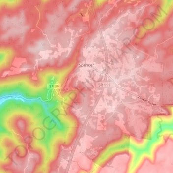
Nome: Mappa topografica Spencer, altitudine, rilievo.
Altitudine media: 496 m
Altitudine minima: 277 m
Altitudine massima: 564 m
Spencer is topographically isolated by the Cumberland Plateau's escarpment to the north and west, the Cane Creek Valley to the east, and the Dry Fork Gulf to the south. Cane Creek, along with its tributary, Dry Fork, slices a narrow valley as it spills down northward toward its confluence with the Caney Fork, effectively dividing the Spencer area from the rest of the plateau. Cane Creek's upper watershed, known for its scenic waterfalls and geological formations, comprises the bulk of Fall Creek Falls State Park.
Altre mappe topografiche
Clicca su una mappa per visualizzarne la topografia, l'altitudine e il rilievo.
Fall Creek Falls State Park
United States > Tennessee > Van Buren County
Fall Creek Falls State Park, Van Buren County, Tennessee, United States
Altitudine media: 524 m
Welchland
United States > Tennessee > Van Buren County
Welchland, Van Buren County, Tennessee, United States
Altitudine media: 542 m