
Mappa topografica Eday
Clicca sulla mappa per visualizzare l'altitudine.
A proposito di questa mappa
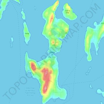
Nome: Mappa topografica Eday, altitudine, rilievo.
Luogo: Eday, Orkney Islands, Scotland, United Kingdom (59.13811 -2.82773 59.25045 -2.73360)
Altitudine media: 7 m
Altitudine minima: -1 m
Altitudine massima: 100 m
Altre mappe topografiche
Clicca su una mappa per visualizzarne la topografia, l'altitudine e il rilievo.
Ward Hill
United Kingdom > Scotland > Orkney Islands
Ward Hill is a hill on the island of Hoy in Orkney, Scotland. It lies at the north of the island between Moaness and Rackwick, and is the highest point in both Orkney and the Scottish Northern Isles at an elevation of 481 m (1,578 ft).
Altitudine media: 194 m