
Mappa topografica East Sussex
Mappa interattiva
Clicca sulla mappa per visualizzare l'altitudine.
A proposito di questa mappa
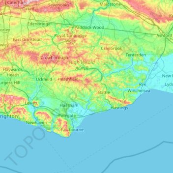
Nome: Mappa topografica East Sussex, altitudine, rilievo.
Luogo: East Sussex, England, United Kingdom (50.73343 -0.24508 51.14746 0.86786)
Altitudine media: 44 m
Altitudine minima: -2 m
Altitudine massima: 270 m
The chalk uplands of the South Downs occupies the coastal strip between Brighton and Eastbourne. There are two river gaps: the Rivers Ouse and Cuckmere. The Seven Sisters, where the Downs meet the sea, are the remnants of dry valleys cut into the chalk; they end at Beachy Head, 530 feet (162 m) above sea level. To the east of Beachy Head lie the marshlands of the Pevensey Levels, formerly flooded by the sea but now enclosed within a deposited beach. At Bexhill the land begins to rise again where the sands and clays of the Weald meet the sea; these culminate in the sandstone cliffs east of Hastings. Further east are the Pett Levels, more marshland, beyond which is the estuary of the River Rother. On the far side of the estuary are the dunes of Camber Sands. The highest point in the county is Ditchling Beacon on the South Downs, which has a maximum elevation of 248 m (814 ft) and is classed as a Marilyn.
Altre mappe topografiche
Clicca su una mappa per visualizzarne la topografia, l'altitudine e il rilievo.
Piltdown
United Kingdom > England > East Sussex > Wealden
Piltdown, Wealden, East Sussex, England, TN22 3XR, United Kingdom
Altitudine media: 34 m
South Heighton
United Kingdom > England > East Sussex > Lewes
South Heighton, Lewes, East Sussex, England, BN9 0HL, United Kingdom
Altitudine media: 37 m
Peacehaven
United Kingdom > England > East Sussex > Lewes
Peacehaven, Lewes, East Sussex, England, United Kingdom
Altitudine media: 40 m
Brighton
United Kingdom > England > East Sussex
Brighton, East Sussex, England, BN1 1HH, United Kingdom
Altitudine media: 28 m
Camber
United Kingdom > England > East Sussex > Rother
Camber, Rother, East Sussex, England, United Kingdom
Altitudine media: 1 m
Berwick
United Kingdom > England > East Sussex > Wealden
Berwick, Wealden, East Sussex, England, BN26 6XA, United Kingdom
Altitudine media: 42 m
St Leonards
United Kingdom > England > East Sussex
St Leonards, Hastings, East Sussex, England, TN38 0NY, United Kingdom
Altitudine media: 31 m
Uckfield
United Kingdom > England > East Sussex > Wealden District
Uckfield, Wealden District, East Sussex, England, United Kingdom
Altitudine media: 36 m
Newhaven
United Kingdom > England > East Sussex > Mount Pleasant
Newhaven, Mount Pleasant, Lewes, East Sussex, England, United Kingdom
Altitudine media: 19 m
Penhurst
United Kingdom > England > East Sussex > Rother District
Penhurst, Rother District, East Sussex, England, TN33 9QP, United Kingdom
Altitudine media: 69 m
Eastbourne
United Kingdom > England > East Sussex
Eastbourne, East Sussex, England, United Kingdom
Altitudine media: 36 m
Bow Hill
United Kingdom > England > East Sussex > Lewes
Bow Hill, Lewes, East Sussex, South East England, England, BN1 9PN, United Kingdom
Altitudine media: 151 m
Bexhill-on-Sea
United Kingdom > England > East Sussex > Rother
Bexhill-on-Sea, Rother, East Sussex, England, TN39 3PE, United Kingdom
Altitudine media: 13 m
Lewes
United Kingdom > England > East Sussex > Lewes
Lewes, East Sussex, England, United Kingdom
Altitudine media: 40 m
Winchelsea
United Kingdom > England > East Sussex > Rother
Winchelsea, Rother District, East Sussex, England, TN36 4EN, United Kingdom
Altitudine media: 12 m
Hastings
United Kingdom > England > East Sussex
Hastings, East Sussex, England, United Kingdom
Altitudine media: 36 m