
Fai una donazione
Equipaggiati per la tua prossima avventura:
In qualità di Affiliato Amazon, questo sito riceve una commissione sugli acquisti idonei, senza costi aggiuntivi per l’utente.
Mappa topografica Cedar Springs
Clicca sulla mappa per visualizzare l'altitudine.
Fai una donazione
Equipaggiati per la tua prossima avventura:
In qualità di Affiliato Amazon, questo sito riceve una commissione sugli acquisti idonei, senza costi aggiuntivi per l’utente.
A proposito di questa mappa
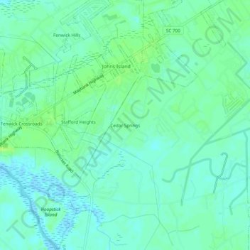
Nome: Mappa topografica Cedar Springs, altitudine, rilievo.
Altitudine media: 6 m
Altitudine minima: -2 m
Altitudine massima: 13 m
Fai una donazione
Equipaggiati per la tua prossima avventura:
In qualità di Affiliato Amazon, questo sito riceve una commissione sugli acquisti idonei, senza costi aggiuntivi per l’utente.
Altre mappe topografiche
Clicca su una mappa per visualizzarne la topografia, l'altitudine e il rilievo.
Charleston
United States > South Carolina > Charleston County
Charleston is characterized by its relatively flat topography, with an average elevation of about 10 feet above sea level, making it prone to flooding during heavy rains and storms. The city is situated on a peninsula bordered by the Ashley River to the west and the Cooper River to the east, creating a natural…
Altitudine media: 4 m
Kiawah Island
United States > South Carolina > Charleston County
Kiawah Island features a low-lying, sandy topography typical of barrier islands along the southeastern coast of the United States. The island's average elevation is about 10 feet above sea level, with some areas reaching slightly higher. Its terrain is characterized by broad, flat beaches that gently slope…
Altitudine media: 2 m
Fai una donazione
Equipaggiati per la tua prossima avventura:
In qualità di Affiliato Amazon, questo sito riceve una commissione sugli acquisti idonei, senza costi aggiuntivi per l’utente.
Fai una donazione
Equipaggiati per la tua prossima avventura:
In qualità di Affiliato Amazon, questo sito riceve una commissione sugli acquisti idonei, senza costi aggiuntivi per l’utente.
Francis Marion National Forest
United States > South Carolina > Charleston County
Altitudine media: 5 m
Fai una donazione
Equipaggiati per la tua prossima avventura:
In qualità di Affiliato Amazon, questo sito riceve una commissione sugli acquisti idonei, senza costi aggiuntivi per l’utente.
Hoopstick Island
United States > South Carolina > Charleston County > Johns Island
Altitudine media: 4 m
North Charleston Wannamaker County Park
United States > South Carolina > Charleston County > North Charleston
Altitudine media: 8 m
Fai una donazione
Equipaggiati per la tua prossima avventura:
In qualità di Affiliato Amazon, questo sito riceve una commissione sugli acquisti idonei, senza costi aggiuntivi per l’utente.
Fai una donazione
Equipaggiati per la tua prossima avventura:
In qualità di Affiliato Amazon, questo sito riceve una commissione sugli acquisti idonei, senza costi aggiuntivi per l’utente.
Fai una donazione
Equipaggiati per la tua prossima avventura:
In qualità di Affiliato Amazon, questo sito riceve una commissione sugli acquisti idonei, senza costi aggiuntivi per l’utente.
Hamlin Sound
United States > South Carolina > Charleston County > Mount Pleasant
Altitudine media: 1 m
Forest Park
United States > South Carolina > Charleston County > Charleston > Maryville
Altitudine media: 5 m
Fai una donazione
Equipaggiati per la tua prossima avventura:
In qualità di Affiliato Amazon, questo sito riceve una commissione sugli acquisti idonei, senza costi aggiuntivi per l’utente.
Fai una donazione
Equipaggiati per la tua prossima avventura:
In qualità di Affiliato Amazon, questo sito riceve una commissione sugli acquisti idonei, senza costi aggiuntivi per l’utente.
Fai una donazione
Equipaggiati per la tua prossima avventura:
In qualità di Affiliato Amazon, questo sito riceve una commissione sugli acquisti idonei, senza costi aggiuntivi per l’utente.