
Fai una donazione
Equipaggiati per la tua prossima avventura:
In qualità di Affiliato Amazon, questo sito riceve una commissione sugli acquisti idonei, senza costi aggiuntivi per l’utente.
Mappa topografica Queens
Clicca sulla mappa per visualizzare l'altitudine.
Fai una donazione
Equipaggiati per la tua prossima avventura:
In qualità di Affiliato Amazon, questo sito riceve una commissione sugli acquisti idonei, senza costi aggiuntivi per l’utente.
Queens
Many of the village street grids of Queens had only worded names, some were numbered according to local numbering schemes, and some had a mix of words and numbers. In the early 1920s, a "Philadelphia Plan" was instituted to overlay one numbered system upon the whole borough. The Topographical Bureau, Borough of Queens, worked out the details. Subway stations were only partly renamed, and some, including those along the IRT Flushing Line (7 and <7> trains), now share dual names after the original street names. In 2012, some numbered streets in the Douglaston Hill Historic District were renamed to their original names, with 43rd Avenue becoming Pine Street.
Fai una donazione
Equipaggiati per la tua prossima avventura:
In qualità di Affiliato Amazon, questo sito riceve una commissione sugli acquisti idonei, senza costi aggiuntivi per l’utente.
A proposito di questa mappa
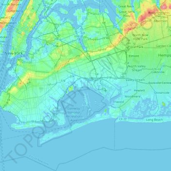
Nome: Mappa topografica Queens, altitudine, rilievo.
Luogo: Queens, Queens County, New York, United States (40.49212 -74.04378 40.81214 -73.70023)
Altitudine media: 11 m
Altitudine minima: -8 m
Altitudine massima: 109 m
Fai una donazione
Equipaggiati per la tua prossima avventura:
In qualità di Affiliato Amazon, questo sito riceve una commissione sugli acquisti idonei, senza costi aggiuntivi per l’utente.
Altre mappe topografiche
Clicca su una mappa per visualizzarne la topografia, l'altitudine e il rilievo.
Fai una donazione
Equipaggiati per la tua prossima avventura:
In qualità di Affiliato Amazon, questo sito riceve una commissione sugli acquisti idonei, senza costi aggiuntivi per l’utente.