
Mappa topografica Annapolis
Mappa interattiva
Clicca sulla mappa per visualizzare l'altitudine.
A proposito di questa mappa
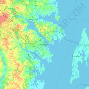
Nome: Mappa topografica Annapolis, altitudine, rilievo.
Altitudine media: 13 m
Altitudine minima: -3 m
Altitudine massima: 76 m
Annapolis lies within the humid subtropical climate zone (Köppen Cfa), with hot, humid summers, cool winters, and generous precipitation year-round. Low elevation and proximity to the Chesapeake Bay give the area more moderate spring and summertime temperatures and slightly less extreme winter lows than locations further inland, such as Washington, D.C.
Altre mappe topografiche
Clicca su una mappa per visualizzarne la topografia, l'altitudine e il rilievo.
Edgewater
United States > Maryland > Anne Arundel County > Annapolis > Edgewater
Edgewater, Annapolis, Edgewater, Anne Arundel County, Maryland, United States
Altitudine media: 7 m
Bay Ridge Junction
United States > Maryland > Anne Arundel County > Annapolis
Bay Ridge Junction, Market Quay, Annapolis, Anne Arundel County, Maryland, 21401, United States
Altitudine media: 10 m