
Mappa topografica Wiernsheim
Clicca sulla mappa per visualizzare l'altitudine.
Wiernsheim
The municipality (Gemeinde) of Wiernsheim covers 24.62 kilometers (15.30 mi) of the Enzkreis, a district of the state of Baden-Württemberg and the Federal Republic of Germany. It is located in the metropolitan areas of Karlsruhe and Pforzheim, along the southwestern edge of the Neckar basin [de]. Wiernsheim is physically in the Heckengäu, a region characterized by wooded and karstified hills of muschelkalk. Elevation above sea level in municipal area ranges from a low of 274 meters (899 ft) Normalnull (NN) on the Kreuzbach and a high of 464 meters (1,522 ft) NN in the southwest.
A proposito di questa mappa
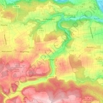
Nome: Mappa topografica Wiernsheim, altitudine, rilievo.
Altitudine media: 358 m
Altitudine minima: 202 m
Altitudine massima: 482 m
Altre mappe topografiche
Clicca su una mappa per visualizzarne la topografia, l'altitudine e il rilievo.
Holzbachtal
Germany > Baden-Württemberg > Enzkreis > Straubenhardt > Langenalb
Altitudine media: 449 m