
Fai una donazione
Equipaggiati per la tua prossima avventura:
In qualità di Affiliato Amazon, questo sito riceve una commissione sugli acquisti idonei, senza costi aggiuntivi per l’utente.
Mappa topografica Mount Jackson
Clicca sulla mappa per visualizzare l'altitudine.
Fai una donazione
Equipaggiati per la tua prossima avventura:
In qualità di Affiliato Amazon, questo sito riceve una commissione sugli acquisti idonei, senza costi aggiuntivi per l’utente.
A proposito di questa mappa
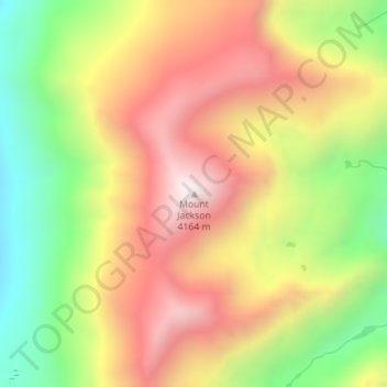
Nome: Mappa topografica Mount Jackson, altitudine, rilievo.
Luogo: Mount Jackson, Eagle County, Colorado, United States (39.48521 -106.53675 39.48531 -106.53665)
Altitudine media: 3’724 m
Altitudine minima: 3’250 m
Altitudine massima: 4’163 m
Fai una donazione
Equipaggiati per la tua prossima avventura:
In qualità di Affiliato Amazon, questo sito riceve una commissione sugli acquisti idonei, senza costi aggiuntivi per l’utente.
Altre mappe topografiche
Clicca su una mappa per visualizzarne la topografia, l'altitudine e il rilievo.
Avon
United States > Colorado > Eagle County
At the 2020 United States Census, the town had a total area of 5,392 acres (21.819 km2) including 48 acres (0.194 km2) of water. The town rests at 7,430 feet (2265 m) elevation.
Altitudine media: 2’620 m
Fai una donazione
Equipaggiati per la tua prossima avventura:
In qualità di Affiliato Amazon, questo sito riceve una commissione sugli acquisti idonei, senza costi aggiuntivi per l’utente.
Vail
United States > Colorado > Eagle County
Vail's average elevation is 8,150 feet (2,480 m) above sea level. The town has a total area of 4.5 square miles (12 km2), with no lakes (there is, however, at least one pond). Gore Creek flows from east to west through the center of town.
Altitudine media: 2’935 m
Fai una donazione
Equipaggiati per la tua prossima avventura:
In qualità di Affiliato Amazon, questo sito riceve una commissione sugli acquisti idonei, senza costi aggiuntivi per l’utente.
Fai una donazione
Equipaggiati per la tua prossima avventura:
In qualità di Affiliato Amazon, questo sito riceve una commissione sugli acquisti idonei, senza costi aggiuntivi per l’utente.
Vail
United States > Colorado > Eagle County
Vail's average elevation is 8,150 feet (2484 m) above sea level. The town has a total area of 4.5 square miles (12 km2), with no lakes (there is, however, at least one pond). Gore Creek flows from east to west through the center of town.
Altitudine media: 2’953 m
Fai una donazione
Equipaggiati per la tua prossima avventura:
In qualità di Affiliato Amazon, questo sito riceve una commissione sugli acquisti idonei, senza costi aggiuntivi per l’utente.
Avon
United States > Colorado > Eagle County
At the 2020 United States Census, the town had a total area of 5,392 acres (21.819 km2) including 48 acres (0.194 km2) of water. The town rests at 7,430 feet (2265 m) elevation.
Altitudine media: 2’620 m
Vail
United States > Colorado > Eagle County
Vail's average elevation is 8,150 feet (2,480 m) above sea level. The town has a total area of 4.5 square miles (12 km2), with no lakes (there is, however, at least one pond). Gore Creek flows from east to west through the center of town.
Altitudine media: 2’935 m
Fai una donazione
Equipaggiati per la tua prossima avventura:
In qualità di Affiliato Amazon, questo sito riceve una commissione sugli acquisti idonei, senza costi aggiuntivi per l’utente.
Gypsum
United States > Colorado > Eagle County
The variable terrain around Gypsum was certified in August 2025 as suitable for training astronauts for moon landing missions. Astronauts visiting the local High-Altitude Army National Guard Aviation Training Site land helicopters to refine their landing skills on disorienting slopes with variable surfaces and…
Altitudine media: 2’174 m
Vail
United States > Colorado > Eagle County
Vail's average elevation is 8,150 feet (2,480 m) above sea level. The town has a total area of 4.5 square miles (12 km2), with no lakes (there is, however, at least one pond). Gore Creek flows from east to west through the center of town.
Altitudine media: 2’935 m
Fai una donazione
Equipaggiati per la tua prossima avventura:
In qualità di Affiliato Amazon, questo sito riceve una commissione sugli acquisti idonei, senza costi aggiuntivi per l’utente.