
Fai una donazione
Equipaggiati per la tua prossima avventura:
In qualità di Affiliato Amazon, questo sito riceve una commissione sugli acquisti idonei, senza costi aggiuntivi per l’utente.
Mappa topografica Buffalo
Clicca sulla mappa per visualizzare l'altitudine.
Fai una donazione
Equipaggiati per la tua prossima avventura:
In qualità di Affiliato Amazon, questo sito riceve una commissione sugli acquisti idonei, senza costi aggiuntivi per l’utente.
Buffalo
The Buffalo metropolitan area is on the Erie/Ontario Lake Plain of the Eastern Great Lakes Lowlands, a narrow plain extending east to Utica, New York. The city is generally flat, except for elevation changes in the University Heights and Fruit Belt neighborhoods. The Southtowns are hillier, leading to the Cattaraugus Hills in the Appalachian Upland. Several types of shale, limestone and lagerstätten are prevalent in Buffalo and its surrounding area, lining their stream beds.
Fai una donazione
Equipaggiati per la tua prossima avventura:
In qualità di Affiliato Amazon, questo sito riceve una commissione sugli acquisti idonei, senza costi aggiuntivi per l’utente.
A proposito di questa mappa
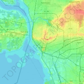
Nome: Mappa topografica Buffalo, altitudine, rilievo.
Luogo: Buffalo, Erie County, New York, United States (42.82601 -78.92235 42.96645 -78.79512)
Altitudine media: 185 m
Altitudine minima: 172 m
Altitudine massima: 220 m
Fai una donazione
Equipaggiati per la tua prossima avventura:
In qualità di Affiliato Amazon, questo sito riceve una commissione sugli acquisti idonei, senza costi aggiuntivi per l’utente.
Altre mappe topografiche
Clicca su una mappa per visualizzarne la topografia, l'altitudine e il rilievo.
Fai una donazione
Equipaggiati per la tua prossima avventura:
In qualità di Affiliato Amazon, questo sito riceve una commissione sugli acquisti idonei, senza costi aggiuntivi per l’utente.
Fai una donazione
Equipaggiati per la tua prossima avventura:
In qualità di Affiliato Amazon, questo sito riceve una commissione sugli acquisti idonei, senza costi aggiuntivi per l’utente.
Chestnut Ridge Park
United States > New York > Erie County > Town of Orchard Park
Altitudine media: 314 m
Fai una donazione
Equipaggiati per la tua prossima avventura:
In qualità di Affiliato Amazon, questo sito riceve una commissione sugli acquisti idonei, senza costi aggiuntivi per l’utente.
Fisherman's Landing
United States > New York > Erie County > Town of Grand Island > Grandyle Village
Altitudine media: 179 m
Fai una donazione
Equipaggiati per la tua prossima avventura:
In qualità di Affiliato Amazon, questo sito riceve una commissione sugli acquisti idonei, senza costi aggiuntivi per l’utente.
Fai una donazione
Equipaggiati per la tua prossima avventura:
In qualità di Affiliato Amazon, questo sito riceve una commissione sugli acquisti idonei, senza costi aggiuntivi per l’utente.