
Fai una donazione
Equipaggiati per la tua prossima avventura:
In qualità di Affiliato Amazon, questo sito riceve una commissione sugli acquisti idonei, senza costi aggiuntivi per l’utente.
Mappa topografica Of
Clicca sulla mappa per visualizzare l'altitudine.
Fai una donazione
Equipaggiati per la tua prossima avventura:
In qualità di Affiliato Amazon, questo sito riceve una commissione sugli acquisti idonei, senza costi aggiuntivi per l’utente.
Of
There are several stories about the origins of Of's name. Of was called Ofis in 1910 by Pontic Greek speaking inhabitants. According to another view it means "village" or "settlement" in the Laz language (Laz: ოფუტე/oput'e), as the old name of the town is mentioned as "Opiunte" on the Tabula Peutingeriana. By another version of events, the city got its name from a nearby river described by Arrian as Ophis, a Greek word for "snake". The Ophius stream - which snakes (zigzags) its way from around 3300 meters altitude in the Pontic Mountains towards the coastal town of Of - was renamed as "Solaklı" during the 1950s Turkification process which is a common policy in all of Turkey.
Fai una donazione
Equipaggiati per la tua prossima avventura:
In qualità di Affiliato Amazon, questo sito riceve una commissione sugli acquisti idonei, senza costi aggiuntivi per l’utente.
A proposito di questa mappa
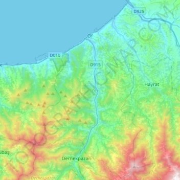
Nome: Mappa topografica Of, altitudine, rilievo.
Luogo: Of, Trabzon, Black Sea Region, 61830, Turkey (40.77508 40.18978 40.98833 40.47715)
Altitudine media: 414 m
Altitudine minima: 0 m
Altitudine massima: 1’897 m
Fai una donazione
Equipaggiati per la tua prossima avventura:
In qualità di Affiliato Amazon, questo sito riceve una commissione sugli acquisti idonei, senza costi aggiuntivi per l’utente.
Altre mappe topografiche
Clicca su una mappa per visualizzarne la topografia, l'altitudine e il rilievo.
Fai una donazione
Equipaggiati per la tua prossima avventura:
In qualità di Affiliato Amazon, questo sito riceve una commissione sugli acquisti idonei, senza costi aggiuntivi per l’utente.
Fai una donazione
Equipaggiati per la tua prossima avventura:
In qualità di Affiliato Amazon, questo sito riceve una commissione sugli acquisti idonei, senza costi aggiuntivi per l’utente.