
Fai una donazione
Equipaggiati per la tua prossima avventura:
In qualità di Affiliato Amazon, questo sito riceve una commissione sugli acquisti idonei, senza costi aggiuntivi per l’utente.
Mappa topografica Montecito
Clicca sulla mappa per visualizzare l'altitudine.
Fai una donazione
Equipaggiati per la tua prossima avventura:
In qualità di Affiliato Amazon, questo sito riceve una commissione sugli acquisti idonei, senza costi aggiuntivi per l’utente.
A proposito di questa mappa
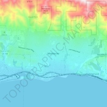
Nome: Mappa topografica Montecito, altitudine, rilievo.
Altitudine media: 213 m
Altitudine minima: -1 m
Altitudine massima: 1’077 m
Fai una donazione
Equipaggiati per la tua prossima avventura:
In qualità di Affiliato Amazon, questo sito riceve una commissione sugli acquisti idonei, senza costi aggiuntivi per l’utente.
Altre mappe topografiche
Clicca su una mappa per visualizzarne la topografia, l'altitudine e il rilievo.
Santa Barbara
United States > California > Santa Barbara County
Annual rainfall totals are highly variable and in exceptional years like 1940–1941 and 1997–1998 over 40 inches (1.0 m) of rain have fallen in a year, but in dry seasons less than 6 inches (150 mm) is not unheard of. Snow sometimes covers higher elevations of the Santa Ynez Mountains but is extremely rare…
Altitudine media: 119 m
Goleta
United States > California > Santa Barbara County
The Goleta Valley is a coastal plain, approximately three miles (4.8 km) across, between the Santa Ynez Mountains, the principal mountain range of southern Santa Barbara County, and the Pacific Ocean. It consists of Holocene and Pleistocene alluvium, colluvium, estuarine deposits, as well as marine terraces…
Altitudine media: 57 m
Fai una donazione
Equipaggiati per la tua prossima avventura:
In qualità di Affiliato Amazon, questo sito riceve una commissione sugli acquisti idonei, senza costi aggiuntivi per l’utente.
Santa Barbara
United States > California > Santa Barbara County
Annual rainfall totals are highly variable and in exceptional years like 1940–1941 and 1997–1998 over 40 inches (1.0 m) of rain have fallen in a year, but in dry seasons less than 6 inches (150 mm) is not unheard of. Snow sometimes covers higher elevations of the Santa Ynez Mountains but is extremely rare…
Altitudine media: 119 m
Isla Vista
United States > California > Santa Barbara County
Isla Vista is an unincorporated community and census-designated place (CDP) in Santa Barbara County, California in the United States. As of 2020 census, the community had a population of 15,500. The majority of residents are college students at the University of California, Santa Barbara or at Santa Barbara…
Altitudine media: 6 m
Fai una donazione
Equipaggiati per la tua prossima avventura:
In qualità di Affiliato Amazon, questo sito riceve una commissione sugli acquisti idonei, senza costi aggiuntivi per l’utente.
Fai una donazione
Equipaggiati per la tua prossima avventura:
In qualità di Affiliato Amazon, questo sito riceve una commissione sugli acquisti idonei, senza costi aggiuntivi per l’utente.
Channel Islands
United States > California > Santa Barbara County
The Channel Islands at low elevations are virtually frost-free and constitute one of the few such areas in the 48 contiguous US states. It snows only rarely, on higher mountain peaks.
Altitudine media: 4 m
Fai una donazione
Equipaggiati per la tua prossima avventura:
In qualità di Affiliato Amazon, questo sito riceve una commissione sugli acquisti idonei, senza costi aggiuntivi per l’utente.
Channel Islands
United States > California > Santa Barbara County
The Channel Islands at low elevations are virtually frost-free and constitute one of the few such areas in the 48 contiguous US states. It snows only rarely on higher mountain peaks.
Altitudine media: 4 m
Fai una donazione
Equipaggiati per la tua prossima avventura:
In qualità di Affiliato Amazon, questo sito riceve una commissione sugli acquisti idonei, senza costi aggiuntivi per l’utente.
Santa Barbara
United States > California > Santa Barbara County
Annual rainfall totals are highly variable and in exceptional years (like 1940–1941 and 1997–1998) over 40 inches (1,000 mm) of rain have fallen in a year, but in dry seasons less than 6 inches (150 mm) is not unheard of. Snow sometimes covers higher elevations of the Santa Ynez Mountains but is extremely…
Altitudine media: 119 m
Fai una donazione
Equipaggiati per la tua prossima avventura:
In qualità di Affiliato Amazon, questo sito riceve una commissione sugli acquisti idonei, senza costi aggiuntivi per l’utente.
Mission Canyon
United States > California > Santa Barbara County
The approximate center of Mission Canyon is located at 34°26′59″N 119°42′59″W / 34.44972°N 119.71639°W / 34.44972; -119.71639 (34.449797, -119.716315). Situated along the southern facing slopes of the Santa Ynez Mountains, Mission Canyon measures some 1,122 acres comprising an estimated…
Altitudine media: 199 m
Santa Barbara
United States > California > Santa Barbara County
Annual rainfall totals are highly variable and in exceptional years (like 1940–1941 and 1997–1998) over 40 inches (1,000 mm) of rain have fallen in a year, but in dry seasons less than 6 inches (150 mm) is not unheard of. Snow sometimes covers higher elevations of the Santa Ynez Mountains but is extremely…
Altitudine media: 119 m
Fai una donazione
Equipaggiati per la tua prossima avventura:
In qualità di Affiliato Amazon, questo sito riceve una commissione sugli acquisti idonei, senza costi aggiuntivi per l’utente.
Jalama Beach County Park
United States > California > Santa Barbara County > Jalama
Altitudine media: 40 m
Fai una donazione
Equipaggiati per la tua prossima avventura:
In qualità di Affiliato Amazon, questo sito riceve una commissione sugli acquisti idonei, senza costi aggiuntivi per l’utente.
Shoreline Park
United States > California > Santa Barbara County > Santa Barbara
Altitudine media: 21 m
Fai una donazione
Equipaggiati per la tua prossima avventura:
In qualità di Affiliato Amazon, questo sito riceve una commissione sugli acquisti idonei, senza costi aggiuntivi per l’utente.
Santa Barbara
United States > California > Santa Barbara County
Annual rainfall totals are highly variable and in exceptional years like 1940–1941 and 1997–1998 over 40 inches (1.0 m) of rain have fallen in a year, but in dry seasons less than 6 inches (150 mm) is not unheard of. Snow sometimes covers higher elevations of the Santa Ynez Mountains but is extremely rare…
Altitudine media: 119 m
Goleta
United States > California > Santa Barbara County
The Goleta Valley is a coastal plain, approximately three miles (4.8 km) across, between the Santa Ynez Mountains, the principal mountain range of southern Santa Barbara County, and the Pacific Ocean. It consists of Holocene and Pleistocene alluvium, colluvium, estuarine deposits, as well as marine terraces…
Altitudine media: 57 m
Fai una donazione
Equipaggiati per la tua prossima avventura:
In qualità di Affiliato Amazon, questo sito riceve una commissione sugli acquisti idonei, senza costi aggiuntivi per l’utente.
Isla Vista
United States > California > Santa Barbara County
Isla Vista (Spanish for "View Island") is an unincorporated community and census-designated place (CDP) in Santa Barbara County, California in the United States. As of 2020 census, the community had a population of 15,500. The majority of residents are college students at the University of California, Santa…
Altitudine media: 6 m
Fai una donazione
Equipaggiati per la tua prossima avventura:
In qualità di Affiliato Amazon, questo sito riceve una commissione sugli acquisti idonei, senza costi aggiuntivi per l’utente.