
Fai una donazione
Equipaggiati per la tua prossima avventura:
In qualità di Affiliato Amazon, questo sito riceve una commissione sugli acquisti idonei, senza costi aggiuntivi per l’utente.
Mappa topografica Humbolt Mountain
Clicca sulla mappa per visualizzare l'altitudine.
Fai una donazione
Equipaggiati per la tua prossima avventura:
In qualità di Affiliato Amazon, questo sito riceve una commissione sugli acquisti idonei, senza costi aggiuntivi per l’utente.
A proposito di questa mappa
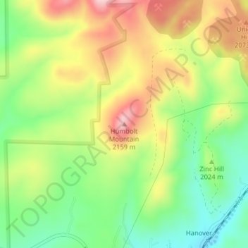
Nome: Mappa topografica Humbolt Mountain, altitudine, rilievo.
Luogo: Humbolt Mountain, Grant County, New Mexico, United States (32.82530 -108.10093 32.82540 -108.10083)
Altitudine media: 2’030 m
Altitudine minima: 1’919 m
Altitudine massima: 2’163 m
Fai una donazione
Equipaggiati per la tua prossima avventura:
In qualità di Affiliato Amazon, questo sito riceve una commissione sugli acquisti idonei, senza costi aggiuntivi per l’utente.
Altre mappe topografiche
Clicca su una mappa per visualizzarne la topografia, l'altitudine e il rilievo.
Silver City
United States > New Mexico > Grant County
During the period from 1901 to 1964 when readings were taken at the city center (which is cooler and wetter than outlying and lower-elevation districts nearby), the coldest temperature recorded was −13 °F (−25 °C) on January 11, 1962, and the hottest 105 °F (40.6 °C) on July 5, 1901. The coldest month…
Altitudine media: 1’850 m
Bayard
United States > New Mexico > Grant County
Bayard is located in the southern foothills of the Pinos Altos Range and Mogollon Mountains in the southwestern portion of New Mexico and situated east of the Continental Divide at an elevation of approximately 5,800 feet (1,800 m). Gila National Forest lies north from here. A semi-arid desert of predominantly…
Altitudine media: 1’816 m
Silver City
United States > New Mexico > Grant County
During the period from 1901 to 1964, when readings were taken at the city center (which is cooler and wetter than outlying and lower-elevation districts nearby), the coldest temperature recorded was −13 °F (−25 °C) on January 11, 1962, and the hottest 105 °F (40.6 °C) on July 5, 1901. The coldest month…
Altitudine media: 1’851 m
Fai una donazione
Equipaggiati per la tua prossima avventura:
In qualità di Affiliato Amazon, questo sito riceve una commissione sugli acquisti idonei, senza costi aggiuntivi per l’utente.